By: Jim Noel
After another hot week (until late this week), a cool down to normal temperatures is expected starting either Oct. 3 or 4 that will last through Oct. 15. Temperatures are expected to return to above normal (but no where near current levels) from Oct. 15-31.
Rainfall will be above normal in northern Ohio this week. The week of Oct. 7 will be normal or below normal but confidence is next week’s rainfall pattern is low to moderate. Above normal rainfall is in the outlook for the second half of October which could slow harvest after Oct. 15.
The hot and drier pattern for a good part of September was caused in part by tropical activity. The remnants of Dorian created a big low pressure system not far from Greenland while a typhoon called Lingling in the western Pacific created a big low pressure near Alaska. This resulted in a hot and dry dome of high pressure over the Southeast U.S. and wet weather in the western corn and soybean belt.
This pattern appears ready to breakdown later this week.
We are moving into frost and freeze season and overall it still looks like a delayed frost and freeze season. Most see their first freeze by Oct. 10-20. Currently, it still looks like a normal to later than normal first freeze.
The November outlook still indicates a warmer than normal month with precipitation not far from normal (but with a lot of uncertainty). We will keep you posted on this.
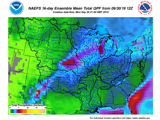
Finally, the two week rainfall outlook from OHRFC can be found here:
https://www.weather.gov/images/ohrfc/dynamic/NAEFS16.apcp.mean.total.png .
It shows the wettest areas being the western two-thirds of the corn and soybean belt. Rainfall for the next two weeks in Ohio will be 1-2+ inches in northern Ohio but generally 0.10-0.50 inches in southern Ohio. Normal is about 1.5 inches for two weeks.
