October 2019 – Weather Prediction

By:  Jim Noel

16 - Day Moisture Forecast

16 – Day Moisture Forecast

After another hot week (until late this week), a cool down to normal temperatures is expected starting either Oct. 3 or 4 that will last through Oct. 15. Temperatures are expected to return to above normal (but no where near current levels) from Oct. 15-31.

Rainfall will be above normal in northern Ohio this week. The week of Oct. 7 will be normal or below normal but confidence is next week’s rainfall pattern is low to moderate. Above normal rainfall is in the outlook for the second half of October which could slow harvest after Oct. 15.

The hot and drier pattern for a good part of September was caused in part by tropical activity. The remnants of Dorian created a big low pressure system not far from Greenland while a typhoon called Lingling in the western Pacific created a big low pressure near Alaska. This resulted in a hot and dry dome of high pressure over the Southeast U.S. and wet weather in the western corn and soybean belt.

This pattern appears ready to breakdown later this week.

We are moving into frost and freeze season and overall it still looks like a delayed frost and freeze season. Most see their first freeze by Oct. 10-20.  Currently, it still looks like a normal to later than normal first freeze.

The November outlook still indicates a warmer than normal month with precipitation not far from normal (but with a lot of uncertainty). We will keep you posted on this.

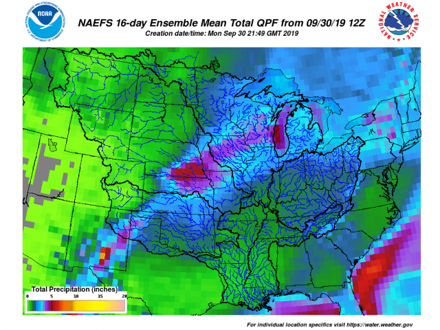
Finally, the two week rainfall outlook from OHRFC can be found here:

https://www.weather.gov/images/ohrfc/dynamic/NAEFS16.apcp.mean.total.png .

It shows the wettest areas being the western two-thirds of the corn and soybean belt. Rainfall for the next two weeks in Ohio will be 1-2+ inches in northern Ohio but generally 0.10-0.50 inches in southern Ohio. Normal is about 1.5 inches for two weeks.

A more normal pattern ahead into August

By Jim Noel (National Weather Service)

June and July together for Ohio will go down as 1-2 degrees warmer than normal and rainfall will go down on average as 100-175% of normal. However, details and timing matter. Looking at July only, rainfall will go down as 75-100 percent of normal over the southwest part of the state while the northern and east will down down as 100-150% of normal.

Average Temperature: Departure from Mean June 1, 2019 - July 27, 2019

Average Temperature: Departure from Mean June 1, 2019 – July 27, 2019

Accumulate Precipitation: Percent of Mean June 1, 2019 - July 28, 2019

Accumulate Precipitation: Percent of Mean June 1, 2019 – July 28, 2019

Over the next two weeks rainfall will be at or slightly below normal in the 1-2 inch range. Rainfall is expected into Tuesday July 30. After that rain event, the next will not occur until about August 6 or 7. The good news is temperatures will be close to normal over the next two weeks. There will be a burst of above normal temperatures this coming weekend though.

Accumulated Precipitation: Percent of Mean June 1, 2019 - July 28, 2019

Accumulated Precipitation: Percent of Mean June 1, 2019 – July 28, 2019

NOAA/Climate Prediction Center 6-10 Day Temperature Outlook

https://www.cpc.ncep.noaa.gov/products/predictions/610day/610temp.new.gif

NOAA/Climate Prediction Center 6-10 Day Rainfall Outlook

https://www.cpc.ncep.noaa.gov/products/predictions/610day/610prcp.new.gif

Two week rainfall totals are expected in the 1-2 inch range as attached graphic shows.

Rainfall Expected

Rainfall Expected

The outlook for August is near normal temperatures and precipitation.

2019 Agriculture Challenges FAQ Webpage Now Live

By Elizabeth Hawkins, OSU Extension

The unrelenting rains this spring and summer have created many challenges that the farming community is now sorting through. In order to help with decisions, OSU Extension has created a Frequently Asked Questions webpage. This page provides the most up-to-date answers to questions about topics ranging from MFP and disaster payments to cover crops, forages, livestock concerns, management of crops that are out of sync with normal planting dates, as well as answers to more questions as information becomes available. There is also an option to submit questions that you would like answered. Webinars with more detailed information will also be shared here. The page is available at go.osu.edu/AgCrisis. Since the situation we are facing is constantly evolving, be sure to check back for the latest information available to help you.

Agronomy and Farm Management Podcast

by: Amanda Douridas, OSU Extension Educator

The Agronomy and Farm Management Podcast has been releasing new episodes every other week since May 2018 and is set to release its 30th episode next Wednesday. To make it easier for listeners to find past episodes, the podcast has a new landing page at http://go.osu.edu/AFM.

Here you will find a listing of all past episodes, descriptions of what we talked about and links to additional resources. We cover a wide range of topics for corn, soybean and small grain farmers on agronomic and farm management topics. Episodes include legal topics such as leases, LEBOR, and hemp; timely seasonal topics like disease, insects and weather; and operational improving strategies related to nutrient management, precision agriculture and grain marketing.

Stay up to date on the latest episodes by following us on Twitter and Facebook(@AFMPodcast) and adding us to your favorites in Apple Podcasts or Stitcher. Give us a good rating and review if you like the podcast! If there is a listening platform you would like us to broadcast on or you have a topic suggestion, reach out on social media or by email at Douridas.9@osu.edu.

Above normal temperatures and precipitation will rule July

By Jim Noel (National Weather Service)

Even though it has gotten a little drier recently, the pattern around a big high pressure to the west and south of Ohio favors a warm and humid July with rain chances. However, there will be swings in the the pattern from week to week. The first week of July will offer a very warm and humid pattern with increasing rain chances. Week 2 will offer a cooler pattern but with continued rain chances. Week 3 and 4 will return to above normal temperatures and rainfall near normal. For the next two weeks, expect the average rainfall to be 2-4 inches across the state which is at or above normal.

Looking ahead to August, expect above normal temperatures with rainfall normal or above normal. It should be noted that the above normal temperatures will be driven much more so by overnight low temperatures versus daytime maximum temperatures. Maximum temperatures will generally only be a few degrees above normal while overnight minimum temperatures will at times be 5-10 degrees above normal.

Wet Weather and Soybean Stands

By:  Laura Lindsey and Alexander Lindsey, Ohio State University

Saturated soils after soybean planting can cause uneven emergence and stand reductions of varying extent depending on the stage of the soybean plant and other environmental factors including temperature and duration of saturated conditions. Additionally, increased disease incidence may further reduce plant stand.Flooded soybean field

Saturated Soil Prior to Germination: While soil moisture is necessary for germination, soybean seeds will not germinate when soils are saturated because oxygen is limiting.

Saturated Soil during Germination: Saturated soils during soybean germination may cause uneven emergence. In a laboratory study, soybean germination was reduced by ~15% after only one hour of flood conditions (Wuebker et al., 2001). After 48 hours of flood conditions, soybean germination was reduced 33-70% depending on when imbibition (seed taking up water) began relative to the flooding conditions. Practically, for Ohio, this means if soybean seeds were further along in the germination process when flooding occurred, the seeds will be more susceptible to flooding stress.

Saturated Soil during Vegetative Stage: Warmer temperatures will cause soybean plants to die faster. At temperatures, 80 degrees and greater, submerged soybean plants will likely due in 24 to 48 hours. However, cool, cloudy days (…and we’ve had plenty this year) and clear nights increase the survival potential of a flooded soybean crop. Flooded plants may also exhibit poor nodulation, resulting in yellow, stunted plants.

Evaluate Stand: To quickly estimate stand, count the number of plants in 69’8” of the row for 7.5-inch row spacing, 34’10” for 15-inch row spacing, or 17’5” of the row for 30-inch row spacing. These counts represent 1/1000th of an acre (i.e., 120 plants in 7.5-inch row spacing = 120,000 plants/acre).

Keep in mind, the effect of plant population on yield is very small over the normal range of seeding rates. For soybeans planted in May, final populations of 100,000 to 120,000 plants/acre are generally adequate for maximum economic return. For example, in our seeding rate trials in Clark County, 100% yield (77 bu./acre) was achieved with a final plant stand of 125,000 plants/acre. However, a 95% yield (73 bu./acre) was achieved with only 77,000 plants/acre. (This trial was planted the second half of May in 15-inch row width.)

Source:

Wuebker, E.F., R.E. Mullen, and K. Koehler. 2001. Flooding and temperature effects on soybean germination. Crop Sci. 41:1857-1861.