Geography on Higher Ground

In August 2021, I celebrated the 30th anniversary of my PhD from Ohio State Geography. In 1991, I left with my PhD to become an Assistant Professor at the University of Utah; a starting gig that lasted over 20 years.  In 2013, when it was time to move on, OSU Geography was recruiting for the first endowed chair in the history of the department, the Bob and Mary Reusche Chair in Geographic Information Science. I applied, was interviewed, and they (surprisingly) offered the position. I am now back where I started, and I’m very proud and happy to be a faculty member in this stellar program.  Interestingly, I now occupy an office that is directly above the basement office where graduate students were crammed during the late 1980s. After three decades, I have arrived 20 feet above where I started. This is an amusing observation, but also a metaphor.

Left: Harvey Miller in 1988.
Right: Harvey Miller in 2017

Geography was very different in the late 1980s: it was a conflicted discipline in search of its soul.  Human and regional geographers criticized the “space cadets” in spatial analysts and the new subfield of Geographic Information Systems. In turn, the cadets had their own criticisms to lob back, while physical geographers and atmospheric scientists watched the slugfest from the sidelines. Meanwhile, Geography was reeling from decades of academic decline and departmental closures.

When I was a PhD student, I had the privilege of taking History of Geographic Thought from Edward J. “Ned” Taaffe, a former AAG President and department Chair who elevated OSU geography. When thinking about writing this blog, I went back to his 1973 AAG Presidential Address, “The Spatial View in Context.” This captures some of the soul-searching and defensiveness of the time: What is Geography? What is our value?  I remember asking one day during the seminar – why do geographers apologize for their existence?

Fast forward to 2021. Geography is a more confident discipline.  We have learned the value of diverse approaches to knowledge instead of skirmishing over who has the only path to the truth. Our external enemies have mostly retreated: few question the value of mapping, GIS and the holistic, integrative perspective of Geography (although higher education has its foes). Interdisciplinarity no longer feels like begging for a place at the table; rather, it is now a valued approach to understanding and addressing the complexity of the world and its problems.  OSU Geography has maintained its traditional foci of human-environment, GIS/spatial analysis and atmospheric science, but we have arrived at a higher place.

We, as geographers, are still faced with the question – what is the core of Geography? What brings us together, besides a common TIU (Tenure Initiating Unit)?  To me, the persistent quantitative/qualitative split in Geography is a false dichotomy, and I am pleased to see the new generation of geographers rejecting this false choice. I am also pleased to see OSU Geography adopt “justice” as a common touchstone for the program: environmental justice, social justice, climate justice and data justice.  This is a crucial, cross-cutting challenge that demands the diverse perspectives encompassed by contemporary Geography.

A strong future for OSU Geography, and Geography at large, means continuing to work on what unites us.  We are on higher ground, but there are still heights left to climb.

Harvey Miller

Bob and Mary Reusche Chair in Geographic Information Science
Professor of Geography and Director, CURA
The Ohio State University

Sustainability in a World of Cities

The 21st century witnessed an epochal event in human civilization: in 2008, the world became majority urban for the first time in history. Urbanization is accelerating: two-thirds of the global population will live in cities by 2030. Some scholars are projecting an essentially urban planet by the end of the century, with 90% of the world population crowded into urban areas.  A world of 10 billion people living predominantly in cities— of which 60% globally have yet to be built —underscores the critical need and immense opportunity for new scientific and policy approaches that can achieve sustainable urban systems.

graphic to demonstrate CMAX Bus service after 6pm

Figure 1: Locations reachable at 6pm on a typical weekday from the Linden neighborhood of Columbus by public transit and walking after new CMax bus rapid transit service. Graphic courtesy of Harvey Miller

Mobility is central to urbanity: transportation is how we organize our cities. While the personal automobile has generated stunning levels of travel and activity over the past century, it has also led to urban transportation systems being inefficient, costly, inequitable, unsafe and unhealthy, and damage environments at local to global scales.  This is leading to a mobility crisis that will get worse as the world continues to urbanize.

In many cities, we are seeing the deployment of new technology-enabled mobility services such as vehicle sharing, hailing services, and micromobility such as scooters and bikeshare systems. These innovations are disrupting the mobility landscape of cities, with even larger disruptions inevitable with the coming of connected autonomous vehicles.  While these hold promise, they also may make an unsustainable situation even worse.

Are New Mobility Technologies Sustainable?

Introducing disruptive mobility technologies to cities is a large-scale, real-world experiment that will impact cities for decades. The outcomes of these mobility disruptions have profound implications for urban air quality, social equity, energy consumption, greenhouse gas emissions, safety and health.  So far, the evidence is mixed. For example, some evidence suggest that Lyft and Uber are reducing drunk and impaired driving (although possibly at the expense of heavier drinking).  However, these services are also increasing traffic congestion, undermining public transit and leading to higher energy consumption and emissions.

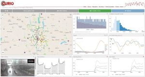
graphic example of data dashboards from available data

Figure 2: The Columbus Urban and Regional Information Observatory (CURIO) – a geospatial data dashboard for Columbus, Ohio. Graphic courtesy of Harvey Miller

Whether new mobility services will make cities more sustainable is an open question, one that will be difficult to answer using 20th century urban scientific and management approaches.  In the past we have relied on simple data and measures that could be easily collected.  For example, automobile traffic counts have been easy to collect: consequently our main transportation performance measure is how many vehicles we can shove through a network.  Our simple, 20th century models also treat mobility as undifferentiated flow, like water – consequently, we made traffic congestion worse by trying to build bigger “pipes” because of a phenomenon known as induced demand.

In the 21st century, we need transportation measures and analytics that:

  • i) focus on people and their activities, not vehicles and their movements;
  • ii) recognize the heterogeneity of peoples’ needs and capabilities with respect to mobility and accessibility, and;
  • iii) capture the full cost of transportation, especially externalities such as emissions, noise, risk and other social and environmental impacts.

New Geospatial Technologies and Sustainable Mobility Science

New sources of data are emerging that could enable some of this system science. Location-aware technologies such as mobile phones and global position system (GPS) receivers, environmental sensors, social media and smart technologies are generating data at unprecedented volumes and spatio-temporal resolution, facilitating new insights into mobility patterns and urban dynamics.  The cost of data storage has plummeted, allowing these data to be saved and archived over time.  Advances in machine learning, geospatial data mining, geovisualization and other knowledge discovery techniques are helping specialized and siloed practitioners work together to make sense of this data avalanche.  Cloud computing, geospatial data portals, application-programming interfaces and data dashboards allow scientists to share these data and information widely with the public. These new technologies are creating a new kind of data-enabled and computation-rich mobility science that can lead to more nuanced, appropriate and sustainable solutions to our growing urban mobility crisis.

Harvey Miller

Bob and Mary Reusche Chair in Geographic Information Science

Professor of Geography

Director, Center for Urban and Regional Analysis (CURA)


Some of the geospatial data-enabled sustainable mobility research projects conducted in the OSU Department of Geography and the Center for Urban and Regional Analysis (CURA) include: