The Asian monsoon, comprised of the South and East Asian subsystems, is a seasonal shift in the rainfall and prevailing wind direction due to the thermal difference between land and ocean. The agriculture, industry, economy, and society at South and East Asia are all critically influenced by freshwater supply from the Asian monsoon. For instance, rice and tea are some crops relying on the summer rainfall that feeds around half of the global population; electricity is produced by hydroelectric power plants driven by water collected during the monsoon season.
Water isotope δ18O – rainfall conundrum
While projections of future Asian monsoon remain largely contradictory due to inadequate comprehension of monsoon dynamics, the paleo Asian monsoon, how monsoon changed in the past, provides empirical constraints on monsoon theories that aids future prediction. Speleothems, also known as cave formations, contain stable water isotope H218O (hereafter expressed as δ18O) inside, which is a proxy (or indicator) of local hydroclimate in the tropics and subtropics. Abundant well-dated speleothem records, uncovered across the pan-Asia continent over the last two decades, reveal an apparently consistent Asian monsoon response during the last deglaciation (20,000 – 10,000 years ago).

Figure. 1. Cross-sections of two stalagmites. Ultra-violet light has been used to illuminate the growth rings in the photo on the right. (Photos: P. Williams)
Starting from the Last Glacial Maximum (LGM, ~20,000 years ago), the δ18O in cave records becomes more enriched during Heinrich Event 1 cooling (H1, ~18,000 – ~14,700 years ago), depletes in Bølling-Allerød warming (BA, ~14,700 – ~12,700 years ago), and becomes enriched again in Younger Dryas cooling (YD, ~12,700 – ~11,700 years ago) (Fig. 2 b and c, black curve). Present-day observations suggest that water isotope δ18O – rainfall relationship Asian monsoon region is a seesaw game. That is, an enrichment of δ18O in speleothems corresponds to a decrease in rainfall, whereas a depletion corresponds to an increase in rainfall. Assuming the relationship constant, the enriched-depleted-enriched speleothem δ18O suggests a dry-wet-dry South and East Asian hydroclimate in H1-BA-YD transition. Some other independent hydroclimate proxies, however, provides us with a dramatically different picture, in which the East Asian monsoon rainfall levels up in H1 and YD but declines in BA, opposite to the South Asia monsoon inferred from speleothem δ18O. In a nutshell, how the hydroclimate evolves over the pan-Asia in the past is largely uncertain and why the δ18Os across the continent are highly coherent is not fully resolved.
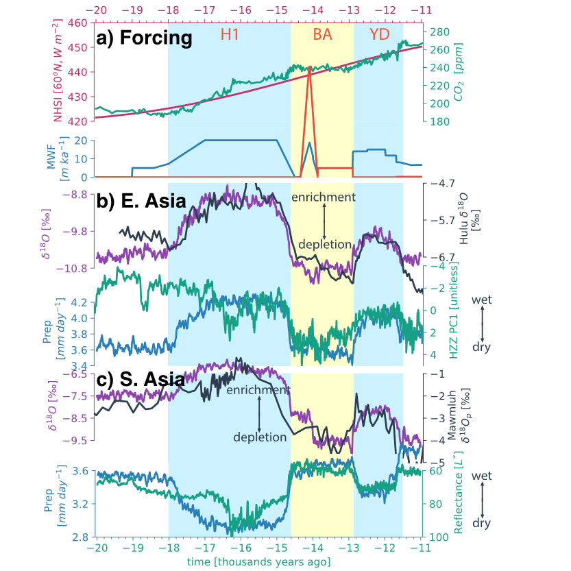
Figure. 2. Good model-data agreement on key features of deglacial climate and δ^18 O evolution. (a) climate forcings: summer solar insolation (red) at 60oN, CO2 concentration (green), and meltwater flux (blue for northern hemisphere and orange for southern hemisphere); (b) hydroclimate at East Asia: simulated water isotope δ^18 O (purple), δ^18 O from speleothem (black) at Hulu cave (120oE, 30.1oN), simulated monsoon rainfall (blue), and the leading PC of Haozhu records (green), a proxy for East Asian monsoon rainfall; (c) hydroclimate at South Asia: simulated water isotope δ^18 O (purple), δ^18 O from speleothem (black) from Mawmluh cave (91.4oE, 25.2oN), simulated monsoon rainfall (blue), and the Arabian Sea sediment total reflectance (green), a proxy for South Asian monsoon strength. (Graphic courtesy of Chengfei He)
Simulation of the last deglacial climate and water isotope
One possible way to understand the deglacial hydroclimate and water isotope δ18O conundrum is to explicitly simulate their past changes by leveraging the state-of-the-art climate model. Climate model is an analogy to computer software that could represent the processes and interactions that drive the Earth’s climate. These cover the atmosphere, oceans, land and ice-covered regions of the planet. Similar to the applications running on your iPhone, climate model is usually running on supercomputers, equipping tens of thousands CPUs. Here, we employ the advanced Community Earth System Model with water isotope enabled (iCESM) to conduct the first set of isotope-enabled transient climate experiments (iTRACE) of the last 20,000 years. The incorporating water isotopes in CESM enables us to simulate the δ18O directly and perform more direct comparisons against the isotopic signals from Asian speleothems.

Figure. 3. Schematic for Climate models that are systems of differential equations based on the basic laws of physics, fluid motion, and chemistry. (NOAA GFDL)
Our simulation quantitively reproduces the water isotope δ18O evolution in speleothem records from South Asia to East Asia (black vs purple curve, Fig. 2b and c). Despite the broadly coherent δ18O evolutions, the simulation suggests an opposite monsoon response across the Asian monsoon region. In agreement with the modern day δ18O – monsoon rainfall relationship, South Asia undergoes an dry-wet-dry transition in H1-BA-YD, while an almost reverse hydroclimate response appears at East Asia (blue curves, Fig. 2b and c), in agreement with other independent hydroclimate proxies (green curves, Fig. 2b and c).
Mechanism of the Asian hydroclimate and water isotope change
Analogy to the engine of our cars that drives vehicle moving forward, the climate is driven by internal or external forcings like greenhouse gas, solar insolation, and meltwater from ice sheet. For example, the anthropogenic global warming is a result of growing emissions of greenhouse gas. The last deglacial climate change is mostly driven by solar insolation and meltwater. Physically, solar insolation slowly intensifies from LGM that triggers the melt of ice sheet, and, in turn, meltwater discharges the ocean via river runoff (Fig. 2a).
The dynamics of Asian monsoon is largely dependent on the thermal difference between the land and surrounding oceans. An increased land-sea thermal contrast leads to an intensified onshore wind bringing abundant moisture and subsequent monsoon rainfall (Fig. 1a), while decreased thermal contrast leads to an offshore wind and therefore suppressed rainfall. Therefore, an increase in solar insolation usually heats the Asian continent more than the ocean, and thus leads to enhanced monsoon such that we see a long-term increasing rainfall trend at South Asia. In contrast, the meltwater forcing usually cools the continent more, and suppresses monsoon rainfall. As such, during the two cold periods: H1 and YD, when massive freshwater discharging the ocean, the South Asian monsoon fails. Opposite to the South Asian monsoon, the East Asian monsoon is associated with westerly jet, a circulation at high-level atmosphere, controlled by sophisticated atmospheric dynamics. Long story short, in response to meltwater forcing, the westerly jet migrates southward and leads to more rainfall during H1 and YD at East Asia, but moves northward and leads to less rainfall in response to solar insolation.
Turning to the coherent water isotope δ18O evolution, our simulation reveals that the δ18O in water vapor over Indian Ocean changes systematically during the last deglaciation. The moisture source for Asian monsoon rainfall mostly stems from the Indian Ocean. As a result, the downstream δ18O evolves highly consistently across the pan-Asia. For example, during H1 and YD, the cooling summer induced by meltwater produces less rainfall over Indian ocean, such that the δ18O in water vapor enriches due to the see-saw δ18O – rainfall relationship. Once the water vapor is transported downstream to Asia continent and condenses, the δ18O enriches in speleothem.