We have just completed week four! The past two weeks were jam-packed with three mapping projects, alumni events, a field trip, and a midterm. We have been very busy! The last two weeks came and went in the blink of an eye, and I cannot believe we only have two weeks left! Here is what we did during week 3 and 4 of field camp!
Week 3 (6/19 – 6/25):
Monday-Wednesday: We started a mapping project Monday morning by Manti, Utah. We had all day in the field on Monday and Tuesday, then a half day on Wednesday. The second half of Wednesday was spent completing our map, cross section, stratigraphic column, and stereographic analysis for our mapping area. This project introduced more complex structure than what we had seen up to that point. There were no partners during this mapping assignment, which helped us each think independently and develop our own skills. It was difficult to see what was going on in this mapping area, and it took most of us until late in the day on Tuesday to really understand the faulting and folding that had occurred. Slowly but surely, we each started to put the pieces together and make sense of the geology we were seeing. Wednesday morning in the field was used to go over what we might have missed, and confirm our hypotheses. After returning from the field, the office work began, and we turned in our project at 10 p.m. One of the boy’s apartments was playing “I Will Survive” in the courtyard during the last few minutes before the project was due, and we cheered and clapped for each other on our way to turning it in. I’m glad we can all have fun even during times of stress.
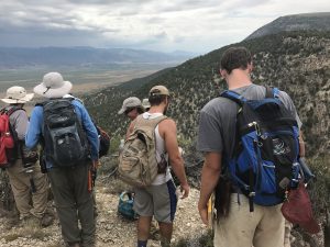
 The students and Dr. Wilson in the field.
Thursday: On Thursday morning we did a core description exercise in Sterling, then spent the rest of the day with the alumni at the Canyon Range. Before the exercise, Dr. Darrah gave a lecture over petroleum geology to help give those of us who hadn’t taken the course a better understanding of the mechanics involved in locating and extracting oil. We then had the opportunity to study a core of the Navajo Formation, which is a reservoir for oil, recovered from the Covenant oil and gas field. After we had finished the exercise, the alumni joined us for lunch. One of the alumni who has worked in the oil and gas industry gave a lecture about sequence stratigraphy and how it applies to petroleum geology. After some time to socialize with the alumni, we made our way to the Canyon Range and hiked up to an overview where we could see a profile of the Canyon Range thrust sheet. Dr. Elliot and Dr. Wilson explained the regional geometry and history of the Sevier fold-thrust belt in Utah to the students and alums.
 The students and alumni in Sterling.
 Dr. Elliot on the overlook at Canyon Range.
Friday-Monday: We started our South Cross Section mapping assignment on Friday morning. This assignment was different that what we were used to because it was a much larger mapping area and we were only concerned with a small strip across the map because the focus of this project was the cross section. Our professors and TAs walked us through the formations while we took lithologic descriptions and attitudes of the rocks all day Friday and Saturday. We saw a total of 13 formations, which were repeated in some areas. Many of the formations we saw were related to the Sevier Orogeny. I think it’s safe to say that we were all confused during the mapping on Friday and Saturday, but once we had the chance to start projecting our data on our cross section it started to make sense. The cross section was hard and very time consuming. This is my favorite project that we have done so far because it required a lot of interpretation, which is challenging but also fun. I like knowing that I can take measurements on the surface of the earth, and use those to project thousands of feet below the surface to better understand the geology and history of an area.
*Friday & Saturday evening: On Friday evening we went to a slide show of previous field camps put on by the alumni. There were many funny pictures, and funny stories that were told along with them. On Saturday evening we had dinner with the alumni. It was a great way to end the 70th reunion celebrations. We were all very fortunate to have the opportunity to meet so many field camp alums. We learned a lot about career options and what it’s like to be a professional geologist. It was said many times by the alumni that field camp was one of the most important and influential experiences they had as geology students. It was nice for us to hear that in the midst of the stress and exhaustion of field camp because it reminded all of us that this is truly a once in a lifetime opportunity.
 Images from the slide show; field camp in the 1960s
 Dr. Darrah thanking the alumni for coming out to the reunion.
Week 4 (6/26 – 7/2)
(Half way done with field camp!)
Monday: Again, Monday was an office day to finish our South Cross Section.
Tuesday-Wednesday: We had our written midterm on Tuesday morning. There wasn’t much time for studying after turning in our project the night before, but we tried our best. After the test was over, we said goodbye to the professors and TAs that taught us for the first half. It was sad to see them go, but we are lucky to have another set of great professors and TAs here to help us learn for the second half of field camp. The rest of Tuesday and all day Wednesday were spent on the Wasatch Range Field Trip. The purpose of this field trip was to learn about regional geology and geological evolution of Utah, including Paleogene arc-related plutonism, basin and range faulting, Lake Bonneville, Quaternary glaciation, and landslides. Our first stop on Tuesday was in Thistle, Utah to look at the massive 1983 landslide that covered the town. The landslide consisted of 28 million cubic yards of material! We then observed terraces on the sides of the mountains which indicate different levels of Lake Bonneville. The next stop was to look at the footwall of the Wassatch Fault and observe the triangular facets which are typical features of normal faults. We learned about the importance of dating earthquakes along these normal faults so a pattern can be established in order to estimate recurrence. Then we went to a location where the surface of the wassatch fault is exposed. On Wednesday we mapped the Alta Stock, an intrusive igneous body that formed about 30 million years ago. We were able to observe the effect this intrusion had on surrounding country rock, which was metamorphosed due to the heat of the igneous body.
 Observing the surface of the Wassatch Fault.
 The 1983 Thistle Landslide.
 Observing and identifying rocks at Alta, Utah.
 Snow at Alta = snowball fight.
 Heading down the trail at Alta.
Thursday-Saturday: We began yet another mapping project on Thursday morning by Salina, Utah. We had two full days in the field, then Saturday was an office day to complete our project. This was by far the most frustrating mapping area yet. Spirits began to dwindle because most of us were still confused after two days in the field. That didn’t stop us though, and we worked all day on Saturday to gain an understanding of the geology in the region through our cross sections. This mapping assignment taught me that even if I don’t understand the structural geology of what I’m looking at, it’s vital that I map as accurately as possible and obtain as much data as I can so that when I’m back home I can put the pieces together.
***
I have never felt more exhausted, but I have also never felt more proud of what I’m accomplishing. I cannot emphasize enough how much I am learning and growing. Not only am I learning geology, but also time management, teamwork, and most importantly I’m learning how to trust in my own observations and knowledge.
-Becky Anderson
 O-H-I-O at Grand Tetons. (Left to right: Cole Bradley, Peter Gordineer, Nick Reineck, and Jasper Mitchin)
 Old Faithful at Yellowstone.
 Grand Prismatic Spring at Yellowstone (My favorite!)
 Grand Canyon of Yellowstone.
 O-H-I-O at The Grand Canyon of Yellowstone. (Left to right: Gus Wulsin, Jasper Mitchin, Casey Clark, and Peter Gordineer)
 Bison at Yellowstone.
 O-H-I-O at Mount Rushmore. (Left to right: OSU alumni we found at Mount Rushmore, Gus Wulsin, Peter Gordineer, and Casey Clark)
 Badlands National Park, South Dakota.


