Grand Tetons, Yellowstone, and Badlands Trip

After field camp ended, we had the option of taking the vans and going on a trip. One van went directly back to Columbus, while three spent a few days exploring and hiking Grand Tetons National Park, Yellowstone National Park, Badlands National park, and Mount Rushmore National Monument.

We had a great time and appreciate the OSU Earth Science department for allowing us to do this. It was a great way to celebrate our accomplishment of finishing field camp. We had the opportunity to see some of the most beautiful national parks and see some incredible geology.

Here are some photos from the trip!

Grand Teton National Park.

O-H-I-O at Grand Tetons. (Left to right: Cole Bradley, Peter Gordineer, Nick Reineck, and Jasper Mitchin)

Old Faithful at Yellowstone.Grand Prismatic Spring at Yellowstone (My favorite!)

Grand Canyon of Yellowstone.O-H-I-O at The Grand Canyon of Yellowstone. (Left to right: Gus Wulsin, Jasper Mitchin, Casey Clark, and Peter Gordineer)

 Bison at Yellowstone.O-H-I-O at Mount Rushmore. (Left to right: OSU alumni we found at Mount Rushmore, Gus Wulsin, Peter Gordineer, and Casey Clark)Badlands National Park, South Dakota.

Bison at Badlands.

Final Week

Final Week (7/17-71/18)

Monday (7/17): We had our final field map exam all day on Monday. Our professors drove us to the mapping area where we were given six hours to map. We were not allowed to talk to other students, and our professors would not answer any questions. This was truly a test of how much we had learned over the past 6 weeks of field camp. It was nerve-wracking, but we each had to trust in our knowledge and trust our gut. Once the field portion was over, we went to a classroom at Snow College in Ephraim to work on our map, cross section, and lithologic descriptions. The day flew by, and before I knew it I had completed the assignment.

Everyone at the final field map exam.

Tuesday (7/18): We had our final written exam on Tuesday morning. Once this was complete, we had to clean our apartments, clean the vans, and pack up. Just like that, field camp was over.

***
The last six and a half weeks have been the most influential and memorable weeks of my undergraduate studies. Even though they were also some of the hardest and most difficult weeks, I look back at everything I learned and gained and I am incredibly thankful that I had the opportunity to have this experience.  I am incredibly proud of myself and my fellow students. We worked hard and pushed through all of the obstacles that came our way. I can officially say I feel like a geologist, which is extremely exciting. I will undoubtedly use the skills and knowledge I gained at field camp in my future. I cannot emphasize enough how much I learned and gained from this experience. Even though I was ready to go home after the 6 weeks in Utah, I am sad that it’s over.

I want to give a huge thank you to our instructors. We were very lucky to have such involved and helpful professors and TAs. It’s a lot of hard work to come out to Utah each summer, and all of your dedication and work is appreciated.


Advice for future field campers:

  • Go into it with an open mind and willingness to learn. It won’t be exactly what you expect, and that’s okay. You will learn more, hike more, and work more than you ever thought you were capable of. There will be an adjustment period, but you will survive!
  • Keep a positive attitude. Having a positive attitude is extremely vital. When you start to become discouraged and negative, it’s tough to come back from. It’s easy to do, but you have to remember that you are at field camp to learn, not to be perfect. I would be lying if I said I was always positive. There were times when I was very frustrated, but I had to take a step back and remind myself that I am a student, not a professional geologist. Mistakes will be made (I made tons of them!), and that’s okay! All that matters is you learn from them and move on.
  • Make friends and be social with the group. The friends I made at field camp are some of the best friendships I have. Everyone is experiencing the same frustration, confusion, and nervousness, so embrace it together.
  • Ask questions! The professors are always willing to help. Don’t be shy! Take advantage of their knowledge because the advice they give you will help you learn.
  • You will not know what is going on when you arrive at a mapping area for the first time. No one does! Don’t worry about it, instead just move forward and work. The geology will make itself clear with time.
  • Most importantly, have fun and enjoy the experience. You get to go to some of the most beautiful areas in the country while at field camp. Take advantage of it and make the time you have in Utah memorable.


Week Six

Week 6 (7/10-7/16)

Monday (7/10): Office day used to finish the North Cross Section.

Tuesday-Friday (7/11-7/15) We started our last mapping assignment on Tuesday morning. It was a very large area and required four full days in the field to complete. The professors took us through a walk through on Tuesday morning, then set us loose after lunch. Since it was the last mapping project, our professors expected us to do a lot more on our own. We used the skills and knowledge we had obtained during the previous five weeks to make our own interpretations. Instead of working individually or in groups of two, we worked in groups of 4-5. This in itself was a learning experience and beneficial for our future work as geologists because the real world requires team work and collaboration. The four days were spent hiking across the mapping area while taking measurements and mapping contacts. This area was complex, and we all had to work hard to understand the geologic history. It was a very difficult but also very rewarding last mapping project.

The group during the morning walk through on Tuesday.

Beautiful view of the mapping area.

Saturday-Sunday (7/15-7/16): Saturday and half of Sunday were used to work on our final mapping assignment. We had to turn in one group map, as well as individual cross sections, lithologic descriptions, and a brief geologic evolution of the area. The second half of Sunday was used to study for the final!


Week Five

Week 5 (7/3-7/9)

Monday-Wednesday: Our last field trip consisted of traveling to Snake Range in Nevada to study a metamorphic core complex on Monday and Tuesday, and going to Great Basin National Park on Wednesday. On Monday we went to Old Man’s Canyon of Snake Range to study both intrusive plutonic rock as well as metamorphosed mylonitic rock which were both a part of the ductile deformation of the metamorphic core complex. We made our way up to the decollement, which separates the ductile and the brittle deformation, while studying the different lithologies and different grades of metamorphism within the rocks as we went. Shear sense indicators were found by studying porphyroclasts, which gave us a better understanding of the stresses that caused the metamorphic core complex to form.

On Tuesday we continued our study of Snake Range by measuring lineations, foliations, joint sets, and faults in order to understand the direction of both ductile and brittle maximum compression and maximum extension. Physically being on a metamorphic core complex is something many professional geologists never get to do. It was an amazing opportunity and learning experience.

On Wednesday we spent time exploring in Great Basin National Park. We first went on a tour of the Lehman Cave in the morning, then had the opportunity to hike various trails before heading back to Ephraim.

The decollement at Snake Range.

Ptygmatic folding seen in metamorphosed rock below the decollement.
   Joint fault sets used to understand the direction of stress.
 Studying the foliations and lineations of Staurolite Garnet Quartz Mica Schist at Snake Range.
Lehman Cave at Great Basin National Park3,000-5,000 year old bristlecone pine tree at Great Basin National Park

Rock Glacier at Great Basin National Park.


Thursday (7/6): This was an office day used to work on our structural analysis of Snake Range. We went to the computer lab and entered the data that we collected from lineations, foliations, joint sets, and faults from Snake Range into a stereonet software which helped us to better understand the types of stresses that caused the metamorphic core complex. We found that both the ductile deformation (linations and foliations) and brittle deformation (joint sets and faults) were a result of the same orientation of stress. This meant that both the brittle and ductile deformation were caused by the same event!

Friday-Saturday (7/7-7/8): We started the North Cross Section on Friday morning, and finished our field work on Saturday evening. We had 24 stops total during the two days in the field, so we had to move quickly and efficiently. A lot of ground was covered, with a lot of formations, contacts, and attitudes.

Looking at a formation during a stop of the North Cross Section.

Taking strikes and dips of a formation.

Petroglyph found during North Cross Section.

Sunday (7/9): This was an office day to work on the North Cross Section. With all of the data from the field, plus three well data points, we were given the task of creating a very large and complex cross section. Just like South Cross Section, we had to interpret the data and create a cross section that not only made geologic sense, but also matched the data we were given. Even though this project was very difficult, I found myself enjoying the challenge. I had to try many wrong options before I figured out the correct geology, and I learned that it’s okay to make mistakes because the mistakes were needed for me to figure out the right answer.

Week Three and Four

We have just completed week four! The past two weeks were jam-packed with three mapping projects, alumni events, a field trip, and a midterm. We have been very busy! The last two weeks came and went in the blink of an eye, and I cannot believe we only have two weeks left! Here is what we did during week 3 and 4 of field camp!

Week 3 (6/19 – 6/25):

Monday-Wednesday: We started a mapping project Monday morning by Manti, Utah. We had all day in the field on Monday and Tuesday, then a half day on Wednesday. The second half of Wednesday was spent completing our map, cross section, stratigraphic column, and stereographic analysis for our mapping area. This project introduced more complex structure than what we had seen up to that point. There were no partners during this mapping assignment, which helped us each think independently and develop our own skills. It was difficult to see what was going on in this mapping area, and it took most of us until late in the day on Tuesday to really understand the faulting and folding that had occurred. Slowly but surely, we each started to put the pieces together and make sense of the geology we were seeing. Wednesday morning in the field was used to go over what we might have missed, and confirm our hypotheses. After returning from the field, the office work began, and we turned in our project at 10 p.m. One of the boy’s apartments was playing “I Will Survive” in the courtyard during the last few minutes before the project was due, and we cheered and clapped for each other on our way to turning it in. I’m glad we can all have fun even during times of stress.

The students and Dr. Wilson in the field. 

Thursday: On Thursday morning we did a core description exercise in Sterling, then spent the rest of the day with the alumni at the Canyon Range. Before the exercise, Dr. Darrah gave a lecture over petroleum geology to help give those of us who hadn’t taken the course a better understanding of the mechanics involved in locating and extracting oil. We then had the opportunity to study a core of the Navajo Formation, which is a reservoir for oil, recovered from the Covenant oil and gas field. After we had finished the exercise, the alumni joined us for lunch. One of the alumni who has worked in the oil and gas industry gave a lecture about sequence stratigraphy and how it applies to petroleum geology. After some time to socialize with the alumni, we made our way to the Canyon Range and hiked up to an overview where we could see a profile of the Canyon Range thrust sheet. Dr. Elliot and Dr. Wilson explained the regional geometry and history of the Sevier fold-thrust belt in Utah to the students and alums.

The students and alumni in Sterling. 

Dr. Elliot on the overlook at Canyon Range.

Friday-Monday: We started our South Cross Section mapping assignment on Friday morning. This assignment was different that what we were used to because it was a much larger mapping area and we were only concerned with a small strip across the map because the focus of this project was the cross section. Our professors and TAs walked us through the formations while we took lithologic descriptions and attitudes of the rocks all day Friday and Saturday. We saw a total of 13 formations, which were repeated in some areas. Many of the formations we saw were related to the Sevier Orogeny.  I think it’s safe to say that we were all confused during the mapping on Friday and Saturday, but once we had the chance to start projecting our data on our cross section it started to make sense. The cross section was hard and very time consuming. This is my favorite project that we have done so far because it required a lot of interpretation, which is challenging but also fun. I like knowing that I can take measurements on the surface of the earth, and use those to project thousands of feet below the surface to better understand the geology and history of an area.

*Friday & Saturday evening: On Friday evening we went to a slide show of previous field camps put on by the alumni. There were many funny pictures, and funny stories that were told along with them. On Saturday evening we had dinner with the alumni. It was a great way to end the 70th reunion celebrations. We were all very fortunate to have the opportunity to meet so many field camp alums. We learned a lot about career options and what it’s like to be a professional geologist. It was said many times by the alumni that field camp was one of the most important and influential experiences they had as geology students. It was nice for us to hear that in the midst of the stress and exhaustion of field camp because it reminded all of us that this is truly a once in a lifetime opportunity.

Images from the slide show; field camp in the 1960s 

Dr. Darrah thanking the alumni for coming out to the reunion.


Week 4 (6/26 – 7/2)

 (Half way done with field camp!)

Monday: Again, Monday was an office day to finish our South Cross Section.

Tuesday-Wednesday: We had our written midterm on Tuesday morning. There wasn’t much time for studying after turning in our project the night before, but we tried our best. After the test was over, we said goodbye to the professors and TAs that taught us for the first half.  It was sad to see them go, but we are lucky to have another set of great professors and TAs here to help us learn for the second half of field camp. The rest of Tuesday and all day Wednesday were spent on the Wasatch Range Field Trip. The purpose of this field trip was to learn about regional geology and geological evolution of Utah, including Paleogene arc-related plutonism, basin and range faulting, Lake Bonneville, Quaternary glaciation, and landslides.  Our first stop on Tuesday was in Thistle, Utah to look at the massive 1983 landslide that covered the town. The landslide consisted of 28 million cubic yards of material! We then observed terraces on the sides of the mountains which indicate different levels of Lake Bonneville. The next stop was to look at the footwall of the Wassatch Fault and observe the triangular facets which are typical features of normal faults. We learned about the importance of dating earthquakes along these normal faults so a pattern can be established in order to estimate recurrence. Then we went to a location where the surface of the wassatch fault is exposed. On Wednesday we mapped the Alta Stock, an intrusive igneous body that formed about 30 million years ago. We were able to observe the effect this intrusion had on surrounding country rock, which was metamorphosed due to the heat of the igneous body.


Observing the surface of the Wassatch Fault.

 The 1983 Thistle Landslide.

Observing and identifying rocks at Alta, Utah.

Snow at Alta = snowball fight.

Heading down the trail at Alta. 

Thursday-Saturday: We began yet another mapping project on Thursday morning by Salina, Utah. We had two full days in the field, then Saturday was an office day to complete our project. This was by far the most frustrating mapping area yet. Spirits began to dwindle because most of us were still confused after two days in the field. That didn’t stop us though, and we worked all day on Saturday to gain an understanding of the geology in the region through our cross sections. This mapping assignment taught me that even if I don’t understand the structural geology of what I’m looking at, it’s vital that I map as accurately as possible and obtain as much data as I can so that when I’m back home I can put the pieces together.

***

I have never felt more exhausted, but I have also never felt more proud of what I’m accomplishing. I cannot emphasize enough how much I am learning and growing. Not only am I learning geology, but also time management, teamwork, and most importantly I’m learning how to trust in my own observations and knowledge.

-Becky Anderson


Week Two

Time is flying by. We have just completed our second week of field camp! During this past week we got our first real taste of working on our own in the field, which was exciting and nerve-wracking! We also took a field trip to Black Rock Desert and Marysvale Volcanic Fields where we learned about igneous rocks and how they are deposited.

Here is a run-down of week two of 2017 OSU Geology Field Camp!

Monday- Wednesday: The first three days of this week consisted of mapping an area south of Ephraim. On Monday we had a nice walk through in order to define the bedding units, as well as describe the lithology of the rocks as a group. After lunch, we went our separate ways with our partners to continue mapping. Once on our own, we had to really utilize the skills that our instructors had taught us, which is easier said than done. By the end of Monday we all had a nice plan in place for the next two days of mapping. Tuesday was another full day in the field, and Wednesday was a half day. The second half of Wednesday was consumed by working on our assignments which were due that night. Working continuously up until the deadline, I realized that this is truly how the real world works. Deadlines are real, and we had to use our time very wisely in order to get all of our work done on time. I’ve never experienced such a rushed feeling with an assignment, and I’m learning how to manage my time which is preparing myself and everyone else for our work as professional geologists in the future. Turning in that assignment was a huge relief and accomplishment. Bring on the next one!

Thursday-Saturday: Our field trip this week was in the Black Desert and Marysvale Volcanic Fields, and surrounding areas. The purpose of this trip was to gain a better understanding of how igneous rock deposits form and what conditions cause the wide variety in compositions and structures we observe. From a structural stand point, we studied two different tectonic environments. We saw calc-alkaline eruption deposition that occurred due to subduction, and bimodal suite depositions that occurred due to extensional environments. We observed both pyroclastic rocks as well as plutonic rocks. A large portion of this trip was looking at the different pulses of energy that a volcanic eruption can have, which causes various depositions of igneous rocks. We learned how to distinguish between an ash fall and ash flow by looking for stratigraphy within the bedding and how to discern how hot a layer was during deposition by looking for clues of welding and induration. Our camp site, Castle Rock Campground, was absolutely beautiful and we spent time studying the deposits there as well. At this location we were able to observe a normal fault that caused a lower (older) unit to be raised while a higher (younger) unit was lowered to be level with each other. I learned so much on this field trip. I was becoming so accustomed to mapping sedimentary rocks that I forgot how incredible igneous rocks are. Even though I have learned so much about igneous rocks through textbooks, this trip opened my eyes to so much more than a textbook ever could. Here are some pictures of the trip!

A collapsed scoria cone.

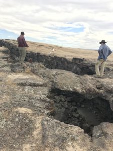
An amazing lava tube, which was once a conduit for flowing lava, but is now a solidified tunnel.

Castle Rock Campground. The distinct formation seen in this image is due to erosion of the Sevier River Formation.

Columnar jointing of Joe Lott Tuff.

I think its safe to say that everyone is exhausted. Most of us are not used to being out in the sun for 9 hours a day and hiking. Even though we are all still adjusting to the routine, spirits are high. Friendships are being made and fun is being had.

Everyone is excited for the 70th reunion activities to begin! Past field camp goers should be arriving this week. We are excited to meet them and learn from their experiences at field camp.

Lastly, I just want to give recognition to our professors and TAs. We are all extremely lucky to have such amazing faculty instructing us. Their knowledge is incredible, and we are all benefiting so much from their help.

Until next week,

Becky Anderson


Week One

I cannot believe that we have already completed a whole week of field camp! I didn’t know how quickly a week could pass until coming here. We are constantly learning and building upon our field skills. Many of us mapped for the first time this week, which was challenging yet rewarding once we started to get the hang of it. Here’s a run down of our first week of field camp.

On Monday we had a practice day on the soccer field of Snow College. The purpose of this was to learn/relearn how to take strike and dip measurements, as well as bearings.

Our first mapping assignment was on Tuesday just outside of Ephraim. We spent a day in the field learning how to map a marker bed, as well as write lithologic descriptions of outcrops. Bearings, sightings, eye heighting, and pacing were all introduced to us (who knew the Bruton could do so much!). I have never been talented at finding myself on a map without GPS, but after learning how to pay attention to key objects on the map, such as fences, trails, gullies, and ridges, I can now locate myself with much more accuracy.

Wednesday consisted of working on our first mapping project, as well as using a software program called Surfer to map our marker bed from the field. The program required us to input points of location and elevation so that it could run a 3-point problem to produce a strike and dip of the bedding. This was then compared to our own data.

Thursday- Saturday was spent on a field trip to Ninemile Reservoir, Salina Canyon, and Capital Reef National Park. The purpose of the trip was to follow the stratigraphic column of South-Central Utah as well as reconstruct depositional environments, describe various sedimentary rocks, and observe fault related folding.


As you can see, it was a busy week! And we have another very busy week ahead. Stay tuned for more details about Field Camp 2017!

-Becky Anderson

Photo taken by Jasper Mitchin

And so it begins…

Hello Everyone!

We have arrived in Ephraim, Utah! The drive was long, but we can all agree that the journey has been a great bonding experience. Everyone is excited and eager to get started tomorrow morning.

The past two days have been busy with hiking and exploring both Arches National Park and Canyonlands National Park.

I am excited to keep you all updated and informed about Ohio State University’s 2017 Geology Field Camp!

-Becky Anderson

*Image: Arches National Park 6/3/17