(An intermittent series introducing well known maps)
Three years earlier, Edward I confirmed the Magna Carta as part of England’s Statute Law.
The Inca Empire continues.
The Aztec Empire begins.
Cahokia (a major ceremonial center) begins to decline.
The Cliff Palace is abandoned.
Dante Alighieri is writing.
A divided Mongol Empire continues.
Marco Polo has returned from China and is writing about his adventures.
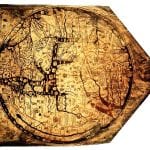
Richard of Haldingham creates the Hereford Mappa Mundi .
Rome has fallen to Northern Forces. In Europe, what classical learning and scholarship that remains, is being preserved by the Christian Church. Maps are part of this hoard. These Mappa Mundi (World Maps) which have survived to the present, did so primarily in manuscripts. Maps from this time period, not surprisingly, are drawn reflecting a Christian point of view.
Starting simply with the world as a flat circular disk, surrounded by an ocean, the “T-O” maps grew more complex as the years passed. In a majority of the maps, East is at the top, with Jerusalem prominently in the center. The top half of the map is Asia, with the large waterways of the Don, the Nile and the Mediterranean Sea dividing Europe and Africa. Theology was more important than geography.
One of the most complex and the largest surviving map is Hereford Cathedral’s Mappa Mundi. It was drawn on one sheet of vellum and is approximately 5ft by 4ft (1.58 x 1.33 metres) in size. Inside the 52 inch circle. the continents form a base map for over 500 images of Biblical events, natural history, other cultures and Classical Mythology. Land shapes on the outer edges of the map have been modified to fit inside the circle. Hereford is on the map, but is almost erased from people touching the location.
Providing assistance to those who could not read, the map teaches Christian history as well as imparting Classical learning. Christ sits at the top of the map judging souls who are being led to heaven by angels and other souls who are being being sent to hell by demons. Just below, on the rim of the circle, lies Eden. It is an inaccessible walled off island. Moving further down (or west), the stories of Noah’s Ark, Exodus and Babylon are depicted. Jerusalem centers the world and the map.
There are depictions of various animals including a lynx, elephant and camel. Clearly important ecclesiastically, Rome is shown with a large building. Paris, a center of learning in Europe, is drawn large too. In all, over 400 cities and towns are named, but the labels for Europe and Africa are switched. Alexander the Great’s war camp is shown as well as the Pillars of Hercules and the Minotaur’s Labyrinth. Interestingly, in the bottom left, a Roman Emperor is sending out surveyors to “Go forth into the whole world and report to the senate on all its parts”.
Although Richard of Haldingham is considered the author, there has been some debate implying it to be the work of several people. Richard was also known as “de Bello” and his younger cousin was also known as Richard de Bello. Could it have been a case of mistaken identity? Or did the younger Richard finish the map? Over 700 years later, it’s hard to say.
The Ebstorf map and the Psalter world map are very similar to the Hereford Mappa Mundi. Sadly, the original and largest known Mappa Mundi, the Ebstorf map was destroyed during WWII. These medieval maps are available at Virtual Mappa .
History West Midlands has created a video about the map.