Reminder! Register for Precision University Today

Source:  John Barker, Amanda Douridas, Ken Ford, John Fulton, Mary Griffith, Will Hamman, Elizabeth Hawkins

Tackling Spring Operations with Reduced Working Days

January 5, the first virtual Precision University event, is quickly approaching. Be sure to register today so you do not miss out on important information to help you improve spring performance. The 2021 focus is “Tackling Spring Operations with Reduced Working Days.” Speakers from around the country will share their research and experience centered on the challenges farmers face during spring with changing weather patterns.

January 5 – Gambling with Planting Decisions – Dr. Aaron Wilson (Ohio State University Extension) and Dr. Bob Nielsen (Purdue University). 1 CCA CM Credit.

January 12 – Improving Fertilizer Efficiency with the Planter Pass – Matt Bennett (Precision Planting Technology) and Dr. John Fulton (Ohio State University). 1 CCA PAg Credit

January 19 – Pre-season Crop Protection Decisions – Dr. Mark Loux and Dr. Scott Shearer (Ohio State University). 0.5 CCA PM and 0.5 PAg Credits.

January 26 – Sprayer Technology to Improve Field Performance – Dr. Joe Luck (University of Nebraska-Lincoln). 1 CCA PAg Credit.

There is no cost to attend Precision University, but registration is required. For more information or to register, visit http://go.osu.edu/PrecisionU. If you have any questions about the Precision U sessions, please feel free to contact Amanda Douridas (Douridas.9@osu.edu).


Spraying with Drones

By John Fulton (Associate Professor), Chris Wiegman (graduate student), Erdal Ozkan ( Professor), and Scott Shearer (Professor), Ohio State University Department of Food, Agricultural and Biological Engineering

Drones or Unmanned Aircraft Systems (UAS) have become a common technology in agriculture. As of early 2019, there were around 1.3 million registered drones in the U.S. and over 116,000 registered drone operators within the commercial sector. Within agriculture, drones have been mainly used for scouting purposes. Today, uses of drones include collecting remotely sensed imagery, tissues samples, and water samples. Spraying with drones is also available through some manufacturers.

Drone spraying has been used Southeast Asian countries such as China, Japan and South Korea for several decades. In fact, the use of this type of spraying in Japan can be traced back to the 90’s. Currently, we are seeing a significant increase in the number of drones used in these countries, mostly in rice production that requires applications done when the field is flooded with water, making entry of motorized vehicle to the field impractical. Drone spraying has also been considered as the most effective and safe way to treat crops grown in steep hills.

Drone spraying is becoming increasingly available for specialty crops and row-crop production. Here is the U.S., drone spraying was approved in 2015, but under strict policies in the state of California. The Yamaha RMAX from Japan was the first drone sprayer tested in California prior to approval. Most recently, drone manufacturers such as DJI (https://www.dji.com/) have started offering high payload rotor drones that include sprayers. Spray applications using drones has arrived in Ohio as well.

Spraying with drones is a unique practice since it is conducted autonomously. Drone sprayers are equipped with almost all the parts of any other sprayer: a tank, a pump to push liquid through the hoses to the nozzles, filters and a pressure gauge. But there are limitations, mostly on the size of these components because of the power required to keep the drone sprayer in flight mode for a reasonable time.

Continue reading

Autonomous Planting Revs Up

Source: DTN/Progressive Farmer

Many of you who have attended our Central Ohio Agronomy School or Precision Ag Symposium have heard Scott Shearer talk about robotic equipment completing our field work.

It is now a reality.

A remote-controlled Kubota M5660SU tractor plants soybeans last week at Bellcock Farms near Sac City, Iowa, while another identical unit heads to the seed tender for a refill. Sabanto, an autonomous technology company, is seeding soybeans in Iowa and Illinois this spring. (Progressive Farmer photo by Matthew Wilde) 

Click here to read full article


How to improve farm productivity with satellite technology in 2020

Effective decision-making requires lots of intellectual resources. Not long ago, the only room for improvement in agriculture was enhancing farming machinery technology and chemical supplement formulas. Now it’s been expanded to the digital field.

What can farmers do to improve their land-use efficiency? 
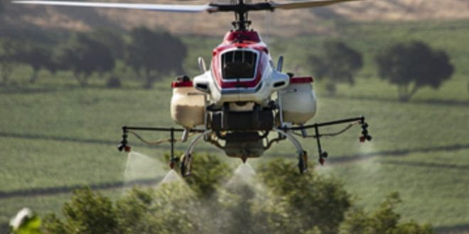
The modern approach suggests using accurate material distribution such as variable rate application techniques, precise weather prediction, and remote sensing for advanced problem-spotting. Satellite monitoring technologies (and crop analysis platforms in particular) are a simple yet cost-efficient entry ticket to the future of farming. Digital tools along with satellite analytics prove especially efficient for big farmers due to good benefit-cost ratio and opportunity to save on scouting. However, it also suits small growers, providing them with a relatively cheap entry to the enterprise-level tech.

Increase profits from your field with crop monitoring platforms.
How satellite imagery and analytics help precision farming transformation?

The most obvious benefit remote sensing and monitoring platforms in particular provide is the comprehensive information that drives field management decision-making. Constantly updated data regarding vegetation health and moisture levels, for example, can point out to spots that need extra watering or fertilization (or have too much of those).

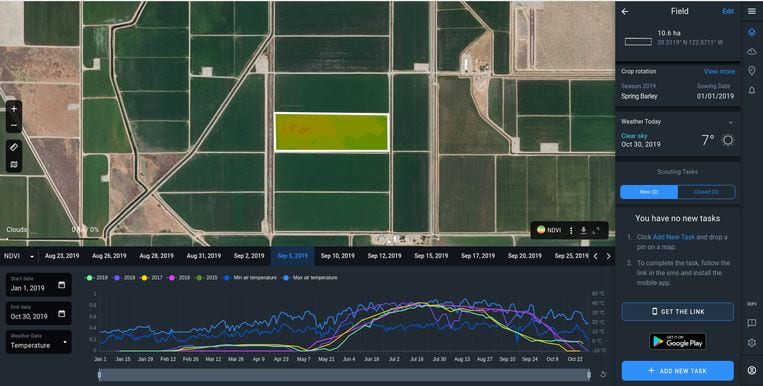
Satellite imagery is also irreplaceable in advanced farming machinery for guidance and variable rate application. For instance, the EOS Crop Monitoring platform features machine learning algorithms that automatically detect and divide fields into crop type category (currently available for Eastern Europe only), calculate field area, and display all the recorded satellite data regarding the field performance and local climate over the past few years upon request. Moreover, it enables to make crop production predictions so that one can make better management decisions.

Machine learning algorithms? What do they have to do with farming?
Satellite imagery takes lots of time to analyze manually, which is why developers train neural networks to automatically recognize the objects’ properties like crop type, field boundaries, and more. The EOS company has proved the data reliability with their comprehensive research and neural network training during the development of the Crop Map project. Crop Map was intended as a part of the World Bank and European Union cooperation with the government of Ukraine to support the agricultural sector transparency in the country. These algorithms helped revealing over 10 million acres of unauthorized land usage area.

  • What can EOS Crop Monitoring tell about your field?
  • With this platform, you can at least facilitate the following:
  • being up-to-date with the state of your crops remotely;
  • being aware in advance about weather changes and risks such as cold or heat stress;
  • optimizing fertilizer application rates;
  • field scouting;
  • measuring precise field area;
  • forecasting yields.
  • How is that possible?

The application allows choosing specific fields to analyze. Then, all the relevant data will be automatically gathered and displayed. Field health information is being monitored through spectral analysis via NDVI, NDSI, and other indices. Precipitation measurements help to assess the soil moisture level while weather indicators (such as wind speed, cloud cover, temperature, and air humidity) will define if that field requires extra care. It can also point out the dependence of culture development on precipitation and temperatures. Interactive graphs with historical weather changes info as well as the forecast for the following days will contribute to field works planning and scheduling. Also, reviewing culture growth historical data allows comparing the regional metrics for yield performance from other fields and forecasting total production volume.

Are there any real cases of using this technology?
EOS Crop Monitoring was the product of choice for Agroprosperis Group (controlled by the American NCH Capital), the largest producer and exporter of wheat, soya, corn and other cultures in the Black Sea region. The company offers financial, growing, storing and exporting services for farmers.

Over the past year, the company has been looking to put Variable Rate Application into practice. By using the satellite imagery they have determined the most productive fields. The decision was to increase the dosage of nitrogen fertilizer to maximize the potential of these fields.

The old strategy implied putting fertilizers evenly distributed among all fields instead of multiplying the output from the best fields and spending fewer resources overall. Plus, 5000-7500 acres of croplands is a huge territory to look after manually. This is why using satellite imagery and crop monitoring was a commercially right decision for the company, as its top-management stated.

How to calculate potential profit from using satellite monitoring?
We know that the average yield in the US from one acre of wheat is around 48 bushels (1306 kg). Let’s review a hypothetical situation. If a 500-acre farm produces 340 tons of crop and the price will average $190 per ton, this field’s owner can lose over $6 000 of income if just 5% of that field fails.

To sum up, satellite analytics and crop monitoring platforms provide an easy and cost-efficient entry into the smart farming trend. Not to mention the fact that they indeed make the life of a farmer easier. And a farm more profitable if the provided information is being used correctly!

Source: https://www.agweb.com/article/how-improve-farm-productivity-satellite-technology-2020


Continue reading

Adopting technology and working together: The future is now for agriculture

“The question is not if a farmer is going to adopt technology, but how and when they are going to adopt technology.” – Dr. Scott Shearer


Check out this article from Ohio’s Country Journal on technology in agriculture featuring Dr. Shearer here:

https://www.ocj.com/2020/02/adopting-technology-and-working-together-the-future-is-now-for-agriculture/

It’s that time of year … Don’t forget to calibrate your yield monitor!

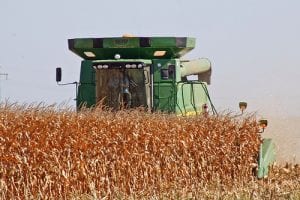
Remember the old adage … Garbage in = Garbage out. Many of us use our yield data to make additional management decisions on our farms such as hybrid or variety selection, fertilizer applications, marketing, etc. Data from an uncalibrated yield monitor can haunt us for many years by leading us into improper decisions with lasting financial affects. In today’s Ag economy we can ill afford any decision with adverse financial implications.

The two biggest reasons I usually hear for not calibrating a yield monitor are 1) I just don’t have time to do it or 2) I can’t remember how to do it without getting my manual out.  While I know it’s easy to criticize from “the cheap seats”, I would argue that this could be some of the most important time you spend in your farming operation each year.  Like many other tasks on our farm, the more we do it, the easier it gets.  Yield monitor data has so much value!  This data provides a summary (in term of yield) of every single decision you made on your farm during the past year.

Below is a calibration checklist created by Dr. John Fulton and Dr. Elizabeth Hawkins.

Continue reading

Finding value in sharing farm data

Source: Jenna Lee and John Fulton

What will sharing my farm data accomplish and what is the value?

Many farmers may find themselves thinking about this very question as they weigh the benefits and drawbacks of sharing their farm data. The potential to realize value from data can often stem from sharing it via digital technologies to service providers or other consultants. In many cases, it may be necessary for a grower to share farm data with multiple entities in order to obtain the largest return on investment possible. While many simple solutions have been presented to farmers that make it easier than ever to share data, the benefits and tangible value of doing so have not been clearly or accurately conveyed.

Sharing data for use in collaborative tools may result in benefits such as:

  • Reducing the number of duplicate datasets generated or collected.
  • Innovative digital tools allow for drawing of site-specific information and learnings.
  • Allowing for one common data source that all decisions can be made from in order to eliminate confusion or inaccurate interpretation from outside sources.
  • Moving from collected data to actionable decisions quickly, and on-the-go.
  • Verifying original analyses and developing new insights from same data.
  • Generating trustworthy, data-backed answers and solutions for complex issues like water quality.
  • Identifying opportunities to improve efficiencies, reduce risk, and increase bottom line.
  • Empowering scientists and researchers to explore and develop new analyses.

Continue reading

Conservation Tillage Conference: March 5-6 in Ada

A world-renowned scientist will be the keynote speaker on the first day of this year’s Conservation Tillage Conference (CTC) in Ada.  Christine Jones, an Australian Soil Ecologist, will be giving the keynote of the annual event with the topic “Building New Topsoil Through the Liquid Carbon Pathway for Long Term Production and Profit.”  The annual conference is scheduled for March 5thand 6th at Ohio Northern University.  The McIntosh Center and Chapel on campus will once again be the location where about 60 presenters, several agribusiness exhibitors, and approximately 900 participants will come together to learn about the latest topics in crop production.

Farmers will be able to choose from four concurrent rooms that will host a variety of speakers from several land grant universities as well as agricultural agency and industry personnel.  Tuesday, March 5th there will be Corn University; Nutrient Management; Precision Agriculture and Digital Technologies; Cover Crops, No-Till, and Soil-Health speakers in each of these rooms.  Wednesday, March 6ththere will be Cover Crops: Issues and Benefits; New Tri-State Fertilizer Recommendations; Soybean School; Water Quality Research and Best Management Practices; Soil Balancing – Is it Important to Manage the Calcium: Magnesium Ratio in Soils?; and Identity Preserved Crops.

The conference fee is $85 for both days ($65 for one day) if paid online by February 21; registration afterwards and day of the event is $80 for one day or $105 for both days.  Registration includes lunch and break refreshments during the day.  Registration information and a detailed program schedule may be found at http://ctc.osu.edu. The detailed program also includes information on continuing education categories for each presentation.  Certified Crop Advisers (CCA) will be able to receive seven hours of continuing education credits each day.  Hours will be offered in all categories, including hard to get categories of Soil and Water Management and Nutrient Management.