The Global River Radar Altimetry Time Series (GRRATS) was developed here at OSU by our group and Prof CK Shum’s group (link). The dataset was developed as part of a NASA MEaSUREs grant led by Dennis Lettenmaier’s group at UCLA (link). Dataset development was led by Steve Coss in our group, and included Steve Tuozzolo in the early phases. Development heavily involved Yuchan Yi and Qi Guo, as well as Yuanyuan Jia in the early phases, in Prof Shum’s group.
The dataset includes over 900 virtual stations (VS) where Jason-2 and EnviSat altimeters cross ocean-draining rivers greater than 900 m in width. These altimeters were designed for measuring ocean elevation, but can (with care) be used to measure river elevations. Dataset construction involved three basic steps. The first step is Geography! The altimeter ground tracks are intersected with large-river centerlines developed by colleague Tamlin Pavelsky’s group at UNC (link). A polygon defining each crossing was drawn manually (by Steve!). This took a long time.

The second step is querying the altimetry Geophysical Data Records. This was handled by Dr. Yuchan Yi’s brilliant software packages which selects altimeter ground track points from the hi-rate data (20 Hz for Jason-2; 18 Hz for Envisat), and applies appropriate corrections to the data (e.g. troposphere delay, solid earth tides, etc.). Data from the Ice-1 retracker are used.
The third step is data post-processing and QA/QC. All altimeter returns for a given pass are averaged, filtered, checked for river ice cover. If the river in question includes a streamgage, then each VS is compared to each gage on the river, and the QA/QC is done quantitatively via error statistics. If no stream gage is available, then each VS is assessed qualitatively by a radar altimetry expert, and a letter grade A-D is assigned. QA/QC was done by Steve!
The dataset is hosted by NASA Jet Propulsion Lab’s Physical Oceanography Distributed Active Archive Center (PO.DAAC). The GRRATS landing page at PO.DAAC is here; there is a link to the FTP at that site.
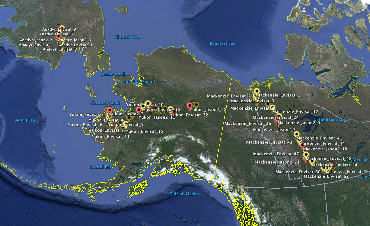
Qi Guo has produced a very useful tool, which allows exploration of the dataset via Google Earth. Each VS is shown as a point in a .kmz file (link). Dataset coverage can be visualized; e.g., here is GRRATS VS for the Yukon, Mackenzie and Amur Rivers; inclusion of Arctic rivers is an outstanding feature of GRRATS, as compared with existing altimetry datesets.
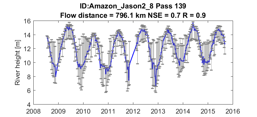
Clicking each VS retrieves quicklook images for each VS. Here is an example quicklook on the Amazon River:
Recent Comments