Posts

Food Security In Olde Towne East

Intro:

The subject of food security is a complicated issue and very nuanced. Every neighborhood is different, and, depending on the size of that neighborhood, there can also exist significant variation within those neighborhoods themselves. Variation also depends a great deal in the socioeconomic conditions of those within a neighborhood in that those with higher income have the ability to expand their access to reliable and healthy food sources often through the ownership of reliable personal vehicles. Poorer individuals and families often struggle to access quality grocery outlets if these outlets are not within a near walk to home or convenient public transit.

The difference in ability to access quality and healthy food due to income makes it difficult to generalize the conditions of a neighborhood in regards to food security. This can be particularly so with neighborhoods in transition–neighborhoods that once experienced significant disinvestment and high levels of poverty but have since seen an increase in new investment and residents. One such neighborhood is Columbus’s Olde Towne East. Located just east of the downtown area and of Interstate 71, it extends more or less from Broad St. in the north, to I-70 in the South, and Champion Avenue in the east. This being said, the local concept of the neighborhood on the part of Columbus and OTE residents varies and often overlaps with other neighborhoods such as Franklin Park and the King-Lincoln District.

Olde Towne East street map as defined by Google Maps

Olde Towne East location in relation to Downtown Columbus and OSU


Most homes in the area were built around of the turn of the 19th to 20th centuries and was among Columbus’s wealthiest. The neighborhood boasts many beautiful brick mansions. The wealthiest street was once Broad St. which was known as a very beautiful and exclusive street to live on. Bryden Rd. also had a great deal of wealthy homes for those unable to live on Broad. Unfortunately, the neighborhood fell into a great deal of disrepair, crime, and poverty as residents moved out to newer suburban areas. Recently though, OTE has experienced renewed investment interest with many new residents living in the historic mansions and new apartment building, and who are making use of numerous restaurants and bars. Walking the streets of the neighborhood demonstrates obvious differences among residents. There are clearly many wealthy residents living in homes well over $200,000 or renting for $1,500+ while still many homes in certain areas remain in disrepair and many live in apartments paying not more than $900 per month for rent. This mix of the “well-off” and those who are not so much, makes for the necessity to consider two possible scenarios for residents of OTE regarding food security–those who have access to a car and sufficient income to purchase healthy food and those without access to a car and may struggle to put food on the table.

Historic Mansions on Bryden Rd.

Neighborhood Structure: 

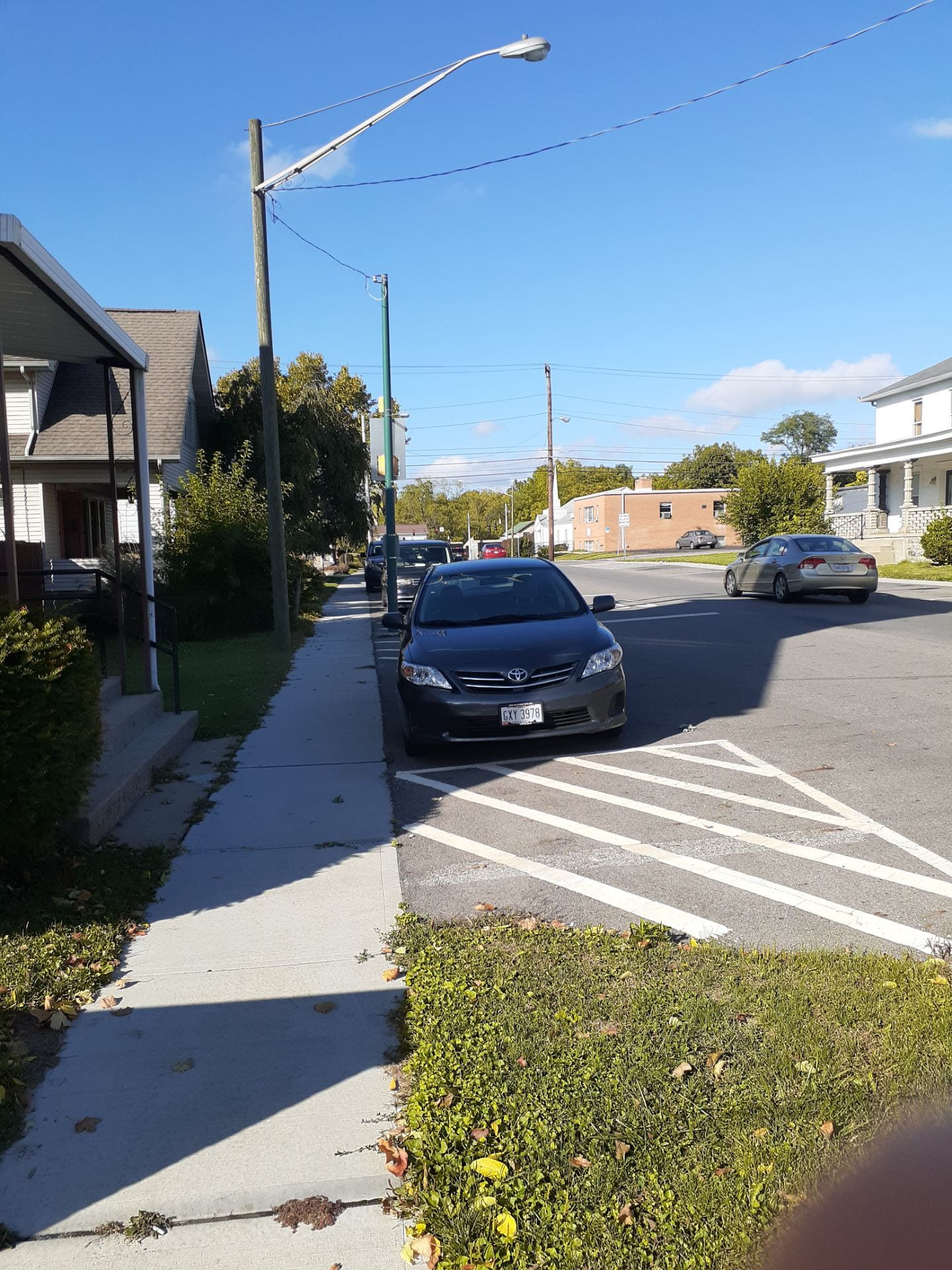
Perhaps one of the greatest potential advantages for food security in OTE is its relative density. The blocks within the neighborhood are compact and lined with sidewalks, street lights, and has relatively good ADA compliance. There is significant public transit access within the neighborhood with bus lines on Main St., Broad St. and Parsons Ave. principally. Most homes and apartments are not more than a few blocks from areas of commerce (restaurants, bars, barber shops, etc.) or potential areas of commerce that has been neglected such as the Main St. corridor. These areas offer great potential for food sources within the neighborhood.

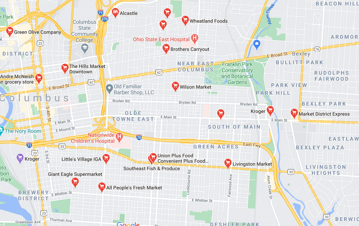
Food outlets in relative proximity to OTE

Healthy Food Access: 

Olde Towne East lacks what would typically be considered healthy food access. The area has corner stores spread throughout, but such outlets often lack in providing quality fruits, vegetables, and meats which are necessary for healthy eating. If one has a car,  helathy food is within a 5-10 minute drive depending on traffic. There are Kroger locations east at Main and Nelson, in German Village, and south on Parsons avenue. There is also a Giant Eagle nearby, but it is set to close soon. In downtown, there is the Hills Market, a local grocery store.

This situation poses a problem for the neighborhood–those who can afford to transport themselves to these relatively distant locations find themselves with access to healthy food. Those who cannot afford it face very long walks, longer times spent in public transit, or only making use of the less healthy food provided by corner stores.

Food Security: 

Residents in OTE are likely to have varying views on food security within the neighborhood depending on their socioeconomic conditions. A wealthier resident might be disappointed at a lack of quality options within the neighborhood itself, but he or she is not likely to feel the same burden of greater travel distance for food that poorer residents do. The thought of insecurity probably seldom crosses their minds if at all. Poorer residents, on the other hand, would much more likely consider their neighborhood food insecure. They have to expend greater time, resources, and effort to access healthy food from grocery stores in other neighborhoods. If they should have access to a private vehicle, this travel is a greater expenditure for them in terms of their overall income than it is for wealthier residents.

OTE is in many ways a food desert, it doesn’t have quality grocery outlets and markets within a reasonable distance for those who walk, use public transit, or may not be able to afford frequent car trips. Although numerous restaurants and bars call the neighborhood home, they by no means equate to healthy food access. It is important to consider that OTE is a small desert surrounded by what could arguably be considered an oasis. Yet, that desert only seems small if you have the resources to leave and access the oasis that surrounds.

Taking Action: 

Acknowledging the disparities and contrasts within Olde Towne East regarding food security does not make the neighborhood’s achievements any less impressive. OTE is a neighborhood that appears to be on the upswing after years of decline, yet there is work to be done to make sure that this upswing is inclusive and beneficial to all people. The fact that there is disparity in the neighborhood is not necessarily bad in that it means that wealthier and poorer residents are living near to one another. This has the potential to bring access to more valuable resources and upward mobility to all within the neighborhood. Stakeholders must work to ensure a continued racial and socioeconomic diversity in the neighborhood by evading the harmful effects of gentrification. This action ensures that poorer residents are able to remain in the neighborhood and benefit from improvements and new investment in the neighborhood.

As for food security specifically, it is advisable to continue to develop a strong local and small business environment in the neighborhood. By using the presence of already established and successful businesses and continued growth in population and investment as catalysts, the neighborhood should work to attract at least 1-2 establishments selling healthy groceries. Such an establishment is more likely to be established and successful in the neighborhood than a large, chain grocery store. Those moving to urban neighborhoods are looking for character and authenticity in their neighborhoods and are attracted to amenities within walking distance of their homes such as coffee shops, restaurants, and bars. Those who are already living in the neighborhood will almost certainly welcome convenient access to healthy food as well when provided. Grocery stores and markets that are able to cater to this preference are likely to be successful. Large grocery stores are not likely to invest in the neighborhood in that they already have invested in areas within a short driving distance and are not often in the business of investing in a neighborhood with the goal of becoming a part of it and improving it. For these reasons, putting effort in attracting local and small business investment has more potential for success.

OTE is a neighborhood with enormous potential. It has seen a golden age, an age of decline, and is seeing an age of rebirth. It is up to the residents of the neighborhood and the greater Columbus community to make sure that this rebirth reaches all those in the neighborhood. Providing access to healthy food such as fresh vegetables, fruits, and meats is one important step of many in ensuring an equitable and upwardly mobile Olde Towne East and Columbus.

The Aspects of Planning

In considering the three aspect of planning–environment, urban design, and transportation–I better realized the connections as well as the distinctions between them. I feel strongly that very nearly, if not all, attributes to each aspect has an impact on other areas. Cities are highly interconnected in their nature, so in planning for the health and wellness of cities, one cannot avoid these connections. In order to determine the attributes, I asked myself “what is/are the goal(s) each aspect seeks to achieve and how do we achieve them?”

I believe that urban design has the goal of making a more pleasant and safe place for people to live. This place must be entertaining which is greatly increased with connectivity between buildings and areas as well architecture that draws the observers’ interests. Land use must be considered and separated to the benefit of residents. Also to benefit residents, greenspace must be incorporated into the design and connects with the environment. The goal of planning for the environment is to have the city have the least amount of negative impacts on the environment and for it to enrich the lives of residents. For this reason, sustainability, green energy, and environmental restoration are integral. CO2 reduction is also highly important, as it is to transportation. In transportation, the central goal is to best connect people and places with the least impact on the environment and built environment. This is why public transit, traffic flow, convenience of transportation options, and sufficient coverage and access of transit are so important. Walkability is integrally related with the urban design and structure of a city. While cycling and trails is most often considered with the environment in mind.

I feel that our CitySkylines simulation more or less touches on the connections between these three aspects. For example, without quality transit and sufficient traffic flow, the city will suffer. If land uses are not separated enough, residents will grow sick from pollution and not wish to live in certain neighborhoods. If there’s not enough police coverage, the city suffers less safety and higher crime. I do feel, though, that the simulation lacks the ability to more concretely comprehend the connection between these aspects. It is not possible to study and quantify CO2 reduction and then realize the impact of transit on it. Nor can we get a strong enough feel for the walkability of our neighborhoods as you would in the real world. This is the problem entirely with the simulation and not the simulation’s fault… you simply cannot substitute for the reality of the real world.


Neighborhood Planning Field Assessment: Central Reynoldsburg

For my field assessment, I chose to walk through my hometown of Reynoldsburg. Reynoldsburg sits approximately 10 miles due east of Downtown Columbus. I  walked through what I am calling Central Reynoldsburg. Although it’s not an official designation, I feel it’s appropriate considering that it contains the historic center, the municipal government center, commerce, and residences in what is the most walkable area of the city. I have designated five areas on my walk that possess enough differing qualities from one another to be noted as distinct and to which I will frequently refer. They are: Olde Reynoldsburg Main Street (lining Main St. between Waggoner Rd. and Blacklick Creek), Central Commercial (lining Main St. between Blacklick Creek and Aida Dr.) , Reynoldsburg Shopping Center (Mains St. between Aida Dr. and Briarcliff Dr.) , Briarcliff Residential (Neighborhood extending north of Main between Briarcliff Dr. and Aida Dr.) , and Olde Reynoldsburg Residential (Extends south of Main St. between Blacklick Creek and Waggoner Rd.) A map is attached above for reference, but for more detail, follow this link https://www.google.com/maps/d/edit?mid=1sKVf5xL5mQxpf-9q09ju0KUPUYEKU9Lx&usp=sharing

Sidewalks:

Olde Reynoldsburg Main Street Sidewalk

Olde Reynoldsburg Residential Sidewalk

Briarcliff Residential Street and Sidewalk

Central Reynoldsburg is well covered with sidewalks and has no observed gaps in coverage. In Olde Reynoldsburg Main Street, the sidewalks are wide enough for approximately three people side by side. They are lined with brick along the curb and they feature semi-frequent placement of flower pots, benches, and bus stops. This same basic design is common for the sidewalks in front of the Reynoldsburg Shopping Center and the Central Commercial Corridor. Both Briarcliff Residential and Olde Reynoldsburg Residential have sidewalks that are slightly more narrow in that they can sustain approximately two people side-by-side. In Briarcliff Residential, the sidewalk is separated from the curb by grass of approximately the same width. In Olde Reynoldsburg Residential, the sidewalks are bordered directly by the curb.

The sidewalk in all the areas are showing signs of decay. The sidewalk is often uneven, cracked, and jagged. For sidewalks lining Main St., this may well be accounted for by construction that has been done on the roadway. Also along Main St., many bricks are damaged or upended. This can be a safety issue and it diminishes the success at beautifying the streetscape.

Improvements could be made in all areas by evening the sidewalks and repairing damage. Laying new bricks, or perhaps getting rid of them entirely, would significantly improve the sidewalks along Main St. Widening the sidewalk in Olde Reynoldsburg Main St. could be beneficial in that it feels tight in spots. Considering that this is a historically walkable district and an area that the city hopes to develop as a destination area with bars and restaurants, without sufficiently wide sidewalks, pedestrians aren’t as likely to feel the area to be inviting and enjoyable.

Street Briarcliff Residential

Street Olde Reynoldsburg Main St.

Street Central Commercial

Street Olde Reynoldsburg Residential

Street Width: 

Along Main St., the streets are four lanes–two lanes for each direction. There are turning lanes on Main St. except for in Olde Reynoldsburg where the buildings line too closely to the street to accommodate them. In Olde Reynoldsburg Residential and Briarcliff Residential, the streets are two ways. In Olde Reynoldsburg, though, these streets are wider to accommodate greater traffic flow. In Briarcliff, the streets are narrower as is typical for a street in a suburban residential neighborhood.

The street width seems adequate in all areas. Traffic flows well in all areas and show no observable signs of needing widened. In Olde Reynoldsburg Main St., it could be a good idea to get rid of narrow parking space along the sides and instead widen the sidewalks. The current layout makes the area feel much more devoted to the car and less pleasant to the pedestrian.

Pedestrians cross without a crosswalk

Flash warning crosswalk Olde Reynoldsburg Main St.

Typical side-street crosswalk along Main St.

Street Safety: 

For the most part, streets seem to be pretty safe for pedestrians. As mentioned, there is concern about damage to the sidewalks that could make them more dangerous. The streets have sufficient pedestrian crossings, yet there are some signs that there should be more in some areas. As seen in the photo above, some pedestrians result to jaywalking in certain areas which demonstrates there’s too large a gap between the two closest crossings.

The existing crosswalks have buttons to indicate the desire to cross and make audible sounds. The crossing time allotted seems adequate to me, but I do walk fast. Elderly people who tend to walk slower may have difficulty crossing in time, but it is difficult to tell without observing.  Most crosswalks stop traffic with a red light, but one in Olde Reynoldsburg Main St. indicates a pedestrian’s desire to cross with a flash warning sign. This feels less safe as it is less clear whether the cars will stop.

Improvements can be made by putting in more crosswalks where there isn’t sufficient coverage. Improvements could also be made at the crosswalk with a flash warning by changing this warning to a full, legal stop for drivers.

Traffic buildup at intersection of Main St. and Lancaster Ave in Olde Reynoldsburg Residential

Street Olde Reynoldsburg Main St.

Traffic Flow:

As mentioned before, traffic appears to flow well through all the areas I walked. On Main Street, there are four lanes (two in each direction) with a turning lane, except for in Olde Reynoldsburg where there are no turning lanes. In both residential areas, there are only two lanes.

In Olde Reynoldsburg Main St., the speed limit is 25 mph as compared to 35 mph along the rest of Main St. Drivers don’t seem to follow the speed limit in this area whereas the other areas they do. I attribute this to a feeling of safety for the drivers. The lanes still feel wide and open in Olde Reynoldsburg Main St., so the drivers feel like there is little need to slow down and to do so feels unnatural. Narrowing the outer lanes or perhaps a tree-lined medium will make drivers feel more constricted and more likely to slow down.

In Olde Reynoldsburg Residential, traffic builds up at intersections with Main St. This is likely due to the streets being only two lanes. Widening the streets could be beneficial, but this doesn’t seem plausible due to constrictions from the built environment.

Olde Reynoldsburg restaurants line Main St.

Olde Reynoldsburg

Olde Reynoldsburg Residences

Setbacks: 

Setbacks in Central Reynoldsburg varies greatly. Along Main St. in Olde Reynoldsburg, there is relatively little setback and the sidewalks line-up directly with the buildings. This creates a much more interesting and inviting walk. Along Main St. in Central Commercial and at Reynoldsburg Shopping Center, the setback grows dramatically. Both areas have parking lots between buildings and the sidewalks, yet, at Reynoldsburg Shopping Center, the parking lot is extremely large and makes for a very long walk from the street to the building. These setbacks make the area much less inviting for pedestrians and much less beautiful.

In both residential areas, there’s also significant setback. The character of these areas is affected a little differently here than how it is on Main St. With grass yards, the setback feels less oppressive and man-made. It feels appropriate for suburban residents and less out of place.

Shops line Main Street

Central Commercial Shops

Restaurant in Olde Reynoldsburg

Building Use: 

Building use throughout Central Reynoldsburg is appropriate for each respective area. In Olde Reynoldsburg Main St., there is a mix of commercial businesses, restaurants, and residences. Many old homes have been transformed here into places of business.

In the Central Commercial area, commerce is the primary use and considering the nature of the built environment, this is the most suitable use. Further west at Reynoldsburg Shopping Center, the use is also commercial. Yet, many of these storefronts sit empty such as an old Kroger location. There’s much potential for redevelopment and an obvious need for a change in use in this neighborhood.

As for both residential areas, the use is obviously residential and appropriate.

New Parking Olde Reynoldsburg Main St.

Large Pakring Lot Reynoldsburg Shopping Center

Parking Central Commercial

Parking: 

In the residential areas of Central Reynoldsburg, most homes have their own driveways for parking and ample street parking.

In Olde Reynoldsburg Main St., parking is much more constrained. Recently, two new parking lots have been built to accommodate business growth in the area. These parking lots, although they are not particularly beautiful and can be damaging to the connectivity of a neighborhood, are necessary due to the need for the car for transit in the area.

Further along Main St. in Central Commercial and at Reynoldsburg Shopping Center, there’s much more parking. In Central Commercial, parking doesn’t take up too much space and is not excessive. At Reynoldsburg Shopping Center, the parking lots are vast and not necessary. They are an eyesore and a waste of space.

To improve parking, I would propose a parking garage in Olde Reynoldsburg so as to increase parking without using too much valuable space. As for Central Commercial, I feel that no changes are necessary. At Reynoldsburg Shopping Center, parking should be greatly reduced in the redevelopment of this decaying shopping center. Any new changes should not create excessive parking nor be so vast as to interrupt the connectivity of the neighborhood.

Traffic buildup at intersection of Main St. and Lancaster Ave in Olde Reynoldsburg Residential

Lack of wheelchair ramp at crossing

Accessibility: 

Reynoldsburg is rather well built to accommodate those with disabilities. Crosswalks all have wheelchair ramps which makes crossing the street safer. I only saw one instance in which there was no wheelchair ramp in Central Commercial. Crosswalk buttons are also at a height that those in a wheelchair can reach.

Again, the need for repairing damage to sidewalk can be dangerous for all and incudes those with disabilities. As such, I feel that in order to improve accessibility for the disabled, repairs must be made to the streets and sidewalks in Central Reynoldsburg.

Underutilized space behind shops

Bike and walking trail

Entrance to JFK Park

Green Space: 

In Central Reynoldsburg, there’s a significant amount of greenspace. There are two parks and a trail. Yet, there’s a great deal of underutilized space that has great potential to be used as greenspace. One particular spot lies behind the stores on Main Street in Olde Reynoldsburg. This spot sits on a hill and overlooks Blacklick Creek. Greenspace would increase the value of these businesses and the overall beauty of the area, but instead there is rundown parking.

More greenspace can increase the beauty of Reynoldsburg and make it much more livable. Not only this, it can increase the value of the properties surrounding it.


Blog 1

Introduction: My city is named Nueva Guaimaca. Nueva Guaimaca is in honor of the city of Guaimaca in Francisco Morazán, Honduras where my girlfriend grew up.

Background: Nueva Guaimaca has grown steadily since its founding. It started as a settlement of just three blocks in a district now known as Elk Square. Expansion pushed largely westward with industrial zones in the south and residential/commercial zones in the north. More recently, expansion has pushed east and includes new oil and agricultural zones.

Population: Nueva Guaimaca has seen steady population growth since its founding in 2020. Currently, the population sits at 57,736. Of that total population, 4,100 are children, 8,855 are teens, 12,044 are young adults, 17,411 are adults, and 14,986 are seniors.

Built Environment

Goal: Improve some major highway interchanges near the primary industrial area.

Action: To address the issue, interchange changes will be made to eliminate 4-way stops and allow traffic to move freely.

Strength: The area already attracts a great deal of investment and has the potential to be a continued source of job growth and tax-income growth.

Weakness: The lack of traffic has weakened the city in that traffic jams have already caused businesses to move out due to delays in the delivery of raw materials.

Opportunity: Two interchanges and one in particular in the southern industrial sector are of great potential.

Threat: Continued issues could cause future businesses to leave and cause unemployment.


Housing

Goal: To more efficiently use already developed space, one area of focus is housing. Many residential buildings are not occupied to capacity so instead of building new buildings, filling existing ones is preferable.

Action: New parks, schools, and medical facilities will be built to make the areas more attractive to future residents.

Strength: There is high demand for residential units.

Weakness: Residential buildings will need to be torn down to make way for new public amenities. To do this, improvements will need to be made in traffic flow as well.

Opportunity: Neighborhoods with low access to parks would be a target.

Threat: More residents will put greater strain on a road network with already high traffic.

Economic Development: 

Goal: Increase tax revenue through continued development of Nueva Guaimaca’s oil industry.

Action: Expand city limits to gain access to new oil fields, build new roads and infrastructure for access, and raise taxes on industrial sector.

Strength: Oil has already become a major export in Nueva Guaiamca’s economy, accounting for nearly a quarter of total exports.

Weakness: Oil is not an infinite resource and cannot be depended on perpetually for revenue. Also, higher taxes may discourage future industrial companies from operating in the city.

Opportunity: Two oil fields exist within the city limits that could be used to grow the industry.

Threat: Significant job loss may occur once the oil industry becomes less viable.

Transportation: 

Goal: Have public transit become primary mode of transportation for city residents.

Action:  Continued addition of new bus lines and the eventual addition of a metro line.

Strength: An existing grid development pattern has created a dense urban environment with great potential for a viable mass transit system.

Weakness: Congestion is causing significant slowdowns in traffic flow.

Opportunity: Some lines have low ridership, route changes and more stops may be beneficial.

Threat: Transit may become too costly for the city budget.

Community Services and Utilities: 

Goal: Improve graduation rate with greater access to schools and universities.

Action: Build new schools and universities in underserved areas.

Strength: 80% of residents are already graduates.

Weakness: Not enough residents have graduated from universities in order to fill available professional positions,

Opportunity: Universities are at capacity and will need constructed most likely east of the highway.

Threat: Education services can put significant strain on the city budget.

Parks and Recreation: 

Goal: All residents have nearby access to parks and other rec facilities.

Action: Build new facilities in underserved areas.

Strength: Most residents already have nearby access to parks and recreation.

Weakness: Industrial areas lack greenspace.

Opportunity: The Financial District and primary industrial zone lack access currently to parks.

Threat: Parks take up space that could have been used for other uses.

Natural Environment: 

Goal: Preserve the natural environment for the beauty of the city and happiness of residents.

Action: Preserve areas within the city from development.

Strength: The city already features many waterways and woodlands.

Weakness: Relatively little natural greenspace has been left undeveloped.

Opportunity: Preserve a wooded area near already developed areas.

Threat: Too much unused space can cause a drain in resources and break up the connectivity of the city.

Future Land Use Plan

Goal: Continue residential and commercial expansion west of areas near Sterling Heights and Oriental District and east of areas near Financial District and Stonehills Plaza. Continue expansion of industrial area to the west.

Action: Develop incrementally using existing strategies.

Strength: An already well-established grid pattern exists.

Weakness: Some areas are rather inaccessible to one another due to separation from the highway.

Opportunity: A lake within city limits has great potential for residential development.

Implementation: 

To achieve the city’s goals, priority will first be given to improvement to traffic issues and access to higher education. Both problems are causing repercussions for employers and the quality of life of residents. Other goals will be worked on incrementally as the opportunity arises following the improvement of other issues. Major projects will be undertaken only if the city budget permits it at that time.

Simulation Versus Reality: 

I do not feel that the simulation reflects well the reality of comprehensive planning. This is because it is simply not possible to simulate the process that needs to be taken to create a comprehensive plan. In the process for making a plan in the real world, it would be improved by rather thorough research in areas such as population forecasts and economic trends. In the simulation, there is no manner by which one can gather data regarding population forecasts and what’s influencing those trends. As for economic trends, one can see, in the simulation, the growth of various industries and some trendlines. Yet, the driving forces are not necessarily known and greater analysis into the economy of the city is not possible.

Also, a lack of working with the community is a major setback to to the simulation. There is no opportunity to organize the community, meet with them, nor receive their input and goals. Without community input, it is near impossible to know of their concerns nor what they want to see achieved in the future. The closest feature to this is the little “tweeter bird” up top, but does not meet the reality of community involvement in the comprehensive planning process.


About Me

Hey everybody,

My name is Marcus Duemmel and I’d like to take a moment to tell you a little bit about myself.

I am a native to the Columbus metro. I was raised and currently live in Reynoldsburg, or the “Burg” as we like to call it. I graduated high school from St. Charles in 2018 and then attended Columbus State. I just graduated from CState in May and will definitely miss it. I had the honor of being an officer for the Latin American Student Association there and was able to get to know a lot of great people because of it. I hope to get involved with a similar group at OSU in the future.

My major here at OSU is City and Regional Planning. I had originally been studying on a path for Civil Engineering, but decided to change. All along I wanted to get a Master’s in City and Regional Planning and that’s still my goal going forward. I decided to take the Innovative Cities class primarily because it’s required for my major, but the content matter is definitely interesting to me and highly useful.


My favorite city I’ve been to is Canada’s capital city, Ottawa. It’s definitely the most beautiful city I’ve visited. Ottawa is situated on the Ottawa River in Ontario, but on the other side is Quebec and specifically the city of Gatineau. My family and I stayed in Gatineau in a hotel just on the other side of the river with great views of Ottawa’s principle sites such as Parliament.

I was immediately impressed by how pleasant the city was. Parks and green-spaces scatter the city throughout such as the bike trail and parks that follow the river for miles. It features a great deal of unique and grand architecture, and lots of great options for urban living. Upon arrival at our hotel, we parked our car and never used it again for the entirety of our stay there. We could easily walk or bike to all sites of interest such as markets, restaurants, and landmarks. It was clear that locals like to avoid cars for their commutes too. On their way to work and about town, I saw locals biking, skateboarding, walking, and even roller skiing. I have read that in the winter they like to ice skate around on the river and canals.

I was probably around 13 when I visited Ottawa, but I would say it was influential in my interest in the planning field. I realized that cities can be more than just a place with a name where you live, but rather a home that makes you happy and healthy. We are happiest when we feel connected to our community and can get to know it beyond what we see through our windshields. Ottawa is a great model in my view for what cities ought to be.