Lower Atmospheric Propagation (LATPROP) Measurement System
LATPROP is large system composed of multiple platforms to study lower atmospheric propagation for radar and communication systems operating in complex non-standard atmospheric conditions. A number of OSU and ONR grants including 3 DURIP grants were used to design and build LATPROP. Total funds used to build LATPROP is approaching $750,000 and currently LATPROP is a very capable system that can perform most radar, scintillation, and propagation loss, and phase-coherent measurements from 2-40 GHz band. The LATPROP subsystems are:
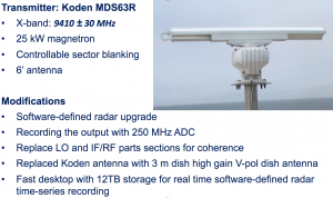
- LATPROP-RADAR: Heavily modified, software-defined, coherent-on-receive, 25 kW marine radar with a high gain 3m dish antenna, and high precision rotor with 0.1 degree accuracy both in elevation and azimuth. Used for sea clutter, radar performance, propagation loss, and scintillation measurements.
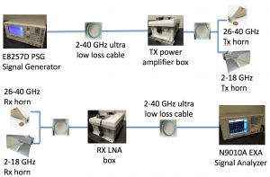
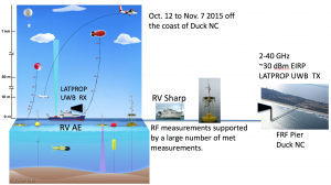
- LATPROP-UWB: 2-40 GHz ultra wide band propagation measurement system composed of high-precision GPS-locked 10 MHz references to synchronize TX and RX systems. Both RX and TX simultaneously do frequency hopping to scan the entire frequency range.
- LATPROP-DRONE: Large stable drone designed for stable RF propagation and scintillation measurements.
(a) LATPROP-DRONE, (b) ASIS buoy (RF transmitter), (c) LATPROP-RADAR, (d.ii) LATPROP-CoVA, (e) controlled towed vehicle (RF transmitter)
- LATPROP-CoVA: 8-element, software-defined radio based, phase-coherent vertical array.
- LATPROP-TD: Medium sized tethered-drone system with meteorological and RF payloads for EM measurements and vertical atmospheric profiling.


