Blog 7: Disaster Training

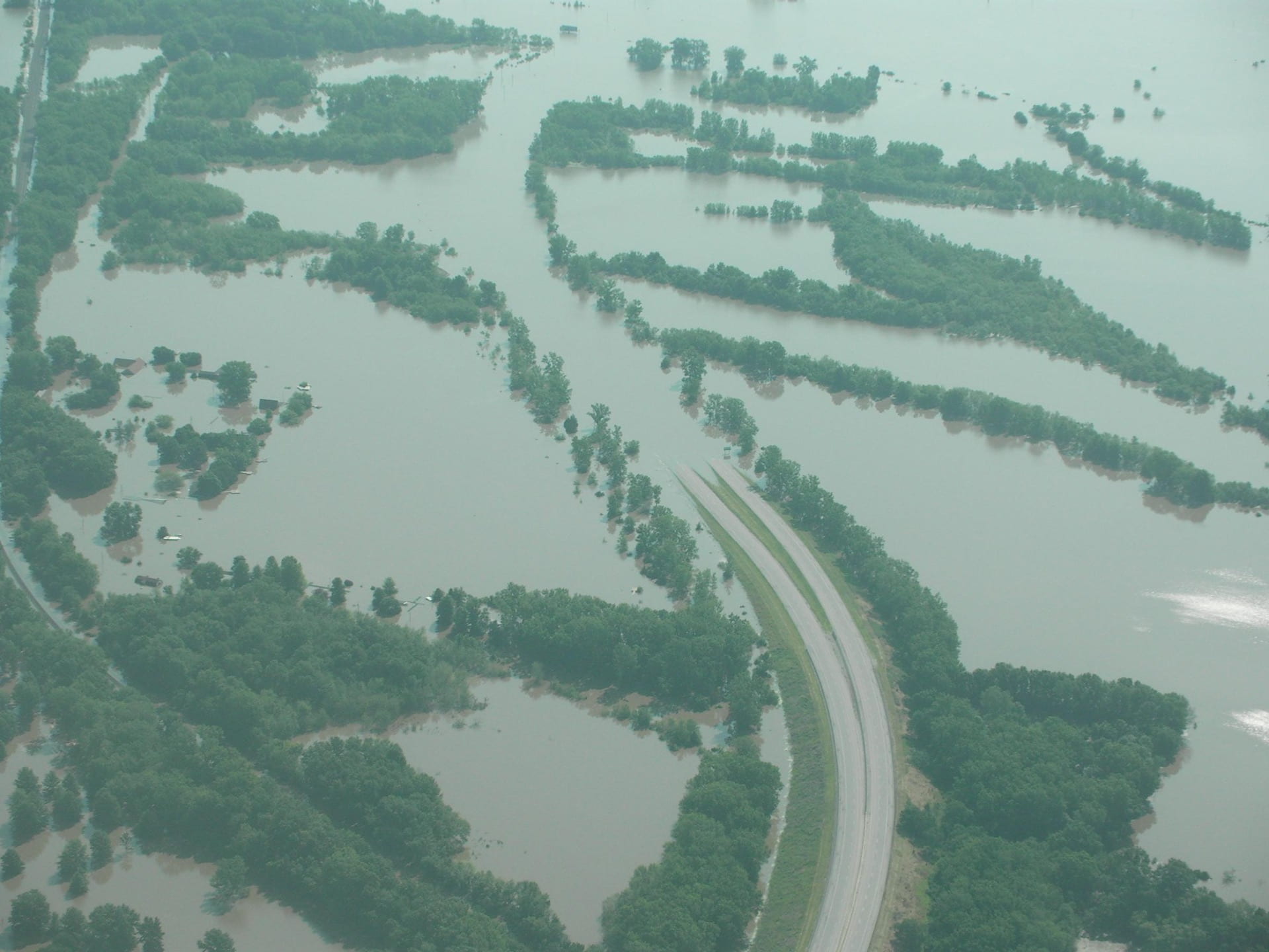
The Great Flood of 1993 was a flood that occurred in the Midwestern United States, along the Mississippi and Missouri rivers and their tributaries, from April to October 1993. Ot left many economic ramifications that would be impact communities for years to come. Over 17 million acres were flooded across nine states across the Midwest during the summer of 1993, starting sometime in June and lasting through August. This is an area larger than the entire state of West Virginia. This long-duration river flooding caused hundreds of levees failures, 50 fatalities and an estimated $15 billion in damages. As a major freight artery in the USA, the river couldn’t be used for freight whilst it was flooded, at a loss of an estimated $2 million per day. On top of this, an estimated $2.6 billion in crops were also lost. Insurance payouts for property losses alone stood at an estimated $12 billion, and an estimated 72,000 homes were flooded along with 62,000 evacuated families. Of the 17 million acres that were flooded, a majority was being used as farmland. This had a long-term impact on the industry as some of the land was not able to be used again for farming for several years after flood waters had receded. High water also rendered some bridges that spanned across the Mississippi River unusable for weeks, disrupting travel across the region. In some cases, this meant taking a detour of over 100 miles just to make it to the other side of a flooded river. Entire towns were destroyed too; Valmeyer and Rhineland were completely destroyed and later relocated to higher ground.

The 1993 Floods had devastating impacts for the midwestern United States as it ruined many aspects of life for people in the area. Interestingly, in both today’s terms and back then, it was recognized as one of the worst floods to ever happen. In August 1993, when the flooding was coming to an end and the cleanup and damage assessment phases were about to begin, B Drummond Ayres Jr. wrote for the New York Times that there was an estimated 12 billion dollars in damage, over 50 lives lost, and nearly 70,000 people losing their homes. Despite the insane damage caused, Ayres Jr writes that the flood never managed to take the people’s spirit away and that once there were signs of the river receding an impressive five feet back, people were “moving in determinedly” to help. It was also estimated that about 800 levees were topped or breached in the areas affected. In 1993, right after the flood, people knew they were in for a lot of damage and that lots of others needed help. Today, with an article reflecting on the floods from Accuweather, written by meteorologist Brian Lada in July 2019, the statistics for the damage is still ridiculous, but at least some light can be shed as to why this happened. Lada writes that more than a year’s worth of rainfall occurred in just a few months. In fact, the rain was “measuring nearly 48 inches of rain between April and August. This is significantly higher than the 35 inches of precipitation that the area typically receives in an entire year.” The Mississippi had reached levels no one thought possible, nearly 50 feet, which Lada states is 20 feet over the flood threshold. Accuweather stats for the flood show that the damage estimated in 1993 was close, but there was over 15 billion dollars of damage. 92 gauges reached all time levels, with 1083 levees topped or failed, quite a few more than predicted in 1993 as well. Through the 186 consecutive days of flooding, 404 counties were declared federal disasters. The pictures that Accuweather has really put the damage and statistics into perspective though. These pictures are haunting. The statistics for the 1993 are absolutely insane, and in 1993, people knew the damage was going to require them to help each other and today those numbers still stand as records. In the end, the 1993 floods will always be recognized as one of the most dangerous floods ever.

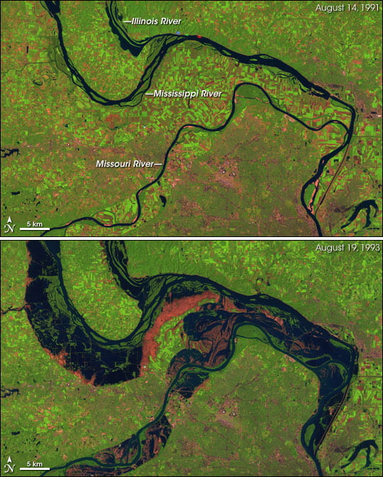
Extremely severe weather and hydrologic conditions led to the flood of 1993. During the first half of 1993, the U.S. Midwest experienced strange heavy rains. Much of the United States in the upper reaches of the Mississippi River drainage basin received more than 1.5 times their average rainfall in the first half of the year, and parts of North Dakota, Iowa, and Kansas experienced more than double that amount. The rains often arrived in very intense storms. Floods overwhelmed the elaborate system of dykes and other water control structures in the Mississippi River basin, leading to the greatest flood ever recorded on the Upper Mississippi. This followed extremely heavy snowfall during the previous winter, which when melting, added to the rainfall runoff entering the river systems. Other factors contributed to the severity of the flooding that year, such as the previous year was cooler than average, which decreased evaporation from the soil and allowed the heavy rains to saturate the ground rapidly. In addition, widespread land cover change along rivers and streams has dramatically altered the natural flood control systems: wetlands that can absorb large amounts of water and release it slowly over time. The network of levees, canals, and dams in the Upper Mississippi Basin was unable to control the floods of 1993. The extreme length of the disaster was also caused by human error as well. Development of many urban areas along the river reduced infiltration, and this increased the risk of damage done to buildings. Channelisation of the river in places such as St Louis exaggerated problems further downstream. Many of the levees along the river weren’t built efficiently, and were breached easily, especially away from major settlements. One man, James Scott was imprisoned for life for causing a catastrophe: his role in flooding of Quincy, Illinois. He removed sandbags from a levee which broke later that day, which resulted in the flooding of 57 square kilometers of farmland.

Disasters are not natural and communities and individuals are able to take measures to prepare themselves to not only minimize damage but also maximize safety. One way all individuals can prepare themselves for a natural disaster is to prepare a backpack with essential items such as: canned food or non perishable goods, water, flashlight, batteries, portable charger, money, multipurpose tool, first aid kit, emergency contact information, and toiletries that can be kept in a secure location in their homes so that should a disaster occur, they have basic necessities for survival. Additionally, individuals can educate themselves on evacuation routes, so that should they be required or encouraged to evacuate, they are already familiar with the route. Individuals, especially those living in disaster prone locations, should invest in insurance such as flood insurance so that should a disaster occur, their belongings will be replaced or be compensated for. Communities can work towards development standards that do not build critical infrastructure within the floodplain. In the case of the 1993 floods, much of the damage from the floods was to agriculture. One way to minimize the risks on a community level is to have federal buyouts in which the government buys flood prone land. Although this can be expensive it is very effective in mitigating the risks associated with floodplains. If the government would have provided more federal buyouts along the Mississippi floodplains prior to the 1993 flood, the loss of life and property damage may have been significantly less. Another way that the community can prepare for a disaster is by implementing development standards that limit building in flood prone areas. In the case of the 1993 floods that affected the Mississippi River, cities and towns along the river could limit the agricultural development which would allow for the land to absorb more of the water from the river flooding, and would limit the devastation to infrastructure caused by the flood waters. The cities and towns along the Mississippi River could also create education programs explaining the buyouts and proposed zoning so that the public can better understand the effects and hazards associated with flooding.

With the several strategies mentioned along comes some potentially barriers that may affect those strategies. One barrier to the evacuation route strategy is that sometimes the shortest best evacuation route can be swarmed with heavy traffic and may take too long. A way of minimizing this is to plan a few evacuation routes and to make sure to evacuate with plenty of time before the disaster is supposed to happen. Another barrier is with the plan of the federal government buying out all the floodplains, the businesses/farms and the communities surrounding the floodplains economic success would be crushed. A way of minimizing this would maybe to have the federal government buyout only the floodplain areas that are in high danger and also have the federal government aid the communities surrounding the flood plan. So that there is less negative economic impact. Another barrier is with the communities developing standards that limit building in the flood prone areas because it would limit the communities to only be able to grow in the other direction and also some of the best agricultural successful land are in those flood prone areas. A way to minimize this would maybe be to only allow them to use the land for agricultural purposes during a certain time of year where the disaster probabilities are lower. Another barrier is with limiting the agricultural development in the flood prone areas to allow the land to absorb more water because the agricultural development in those areas is a main market for the community’s economy. One way to minimize this is, as we suggested before of only allowing agricultural development on the flood prone areas during certain times a year where the probability of disasters is lower.

Blog 6: Planning For Housing

Site 1: New Village Place – 130 Piscitelli Pl. Columbus, OH 43201

New Village Place homes and apartments are located in the Itallian Village and Short North districts, less than two miles away from The Ohio State University and 8 to 9 miles away from both North and South High Street. I would say that the surrounding buildings of the districts are fairly diverse; the property doesn’t necessarily match the architecture and designs of the houses on 71 E 1st Avenue, however there are still a handful of structures that match the same, plain design of the New Village Place property, such as the houses on Robertson Street. I wouldn’t say this is an attractive building; the aesthetics of the apartment building is short of anything unique and don’t really stand out from other surrounding properties in the district. The building, while well furnished, doesn’t really stand out as anything creative or colorful, but rather just as a plain brick building that you can live in. Brick is, of course, one of the main materials used besides wood and concrete for patios, but none of them are used are used in any particular fashion to stand out aesthetically and attract residents from other surrounding properties. The apartment building does try to add some kind of the design, with the front of the structure positioned in a sort of zigzag. We honestly don’t know why this was added in the first place since, due to the no creativity in using the materials, the townhouse is still left looking bland. This time it’s with a little pointless design that no one would bother to point out. Maintenance of the building, however, is fairly well kept. The mulch surrounding the building is laid down well, and none of the bushes are overgrown and ferturding onto the sidewalks. A small plot of land dividing Piscitelli Pl. and E 1st Avenue is also well maintained, with no overgrown grass or misplaced trees that could disrupt the layout of the properties. One thing we’d fix for landscaping are the random dead grass patches, but other than that the landscape’s well maintained. Nearby land use is mostly residential; the village consists of other houses and apartment buildings, and other business are on the busy streets such as High Street, Summit Street and North 4th Street. The nearest grocery store is Kroger, which is a 4 minute drive from the property.

(Land in between Piscitelli Pl. and E 1st Avenue)

(Other surrounding houses on the property)

The New Village Place homes are located in a low crime area when looking at a small buffer area. When looking at a buffer of 500ft there was only 7 crimes surrounding the affordable housing unit. When the buffer grew to 1000ft the crime in the area was over 100. The crime grew to more than 500 when looking at a buffer of .25 of a mile and the crime grew to over 1000 when looking at a buffer of .5 of a mile. There may not be crime surrounding the affordable housing unit right away but as you look at the area in a bigger perspective there is a good amount of crime within a small distance of the homes. The affordable housing unit is located in a low density crime zone as you move to the left of the affordable housing you start to see why there’s so much more crime when the buffer is larger. Moving to the left of the homes there are a couple of areas where the crime becomes very dense. The most common crimes around the affordable housing unit is traffic incidents and burglary from a motor vehicle. When looking at the property values surrounding the affordable housing unit we saw that most of the property values were about the same. The only time we saw a significant increase in the property values was as we got closer to certain districts such as the short north district. The reason for that is the short north is a new developing area that is very attractive to the higher class. The property values surrounding the affordable housing unit are all about the same because the affordable housing unit is well maintained and doesn’t give off the affordable housing feel that people seem to dislike. The schools near the New Village Place homes are the Hubbard Master School which is Pk-6 with a rating of 2 out of 10, the Arts Impact Middle School which is grades 6-8 with a rating of 3 out of 10, and the Fort Hayes Arts and Academic High School which is grades 9-12 with a rating of 3 out of 10. There aren’t many schools in the area surrounding the affordable housing unit most likely due to the fact that the area is not very family oriented. The schools in the area have very low ratings which is also probably due to the fact that it is not a very family oriented area. The affordable housing unit is located in an area where it didn’t have a huge affect on the surrounding property values, also its out of the main area of crime, and its near a couple decent schools. Overall the New Village Place homes are located in a spot that makes sense to have affordable housing.

Site 2: Weinland Park Homes – 1215 N Grant Ave. Columbus, OH 43201

Weinland Park Homes are located east of campus, only 2 blocks off of 4th street. The aesthetics of the homes are somewhat uniform, with wood siding but each is unique in that the colors are different for each home. The surrounding area around Weiland Park Homes consists of empty lots directly across from Grant Avenue. The only building on Grant Ave. other than the homes is an apartment building which does not fit the aesthetic of the surrounding homes because it is of metal and brick construction. The Weiland Park Homes fit the scale of the greater Weinland Park neighborhood. I find the homes in Weinland Park Homes to be very attractive and aesthetically pleasing compared to other affordable housing options in Franklin County. The properties are well maintained with the landscaping kept tidy with shrubs, trees, flowers and other features being maintained well. The lawns of the homes are trimmed and green indicating that they are also well maintained. Each home has their own detached garage for accessible off street parking, as well as available on street parking for guests. Trees line the area between the sidewalk and the road and include lightposts for illumination at night. The backyards are fenced in providing the residents with privacy. There are buildings on nearby 5th Ave. including: Harris Paper Crafts, Columbus Medical Equipment, National Seating and Mobility. The nearest grocery store is Kroger on High St., which is only 0.8 miles away.

For the Weiland Park Homes, the crimes near the homes themselves are actually extremely rare. Within the 500ft range, there were only 4 total crimes within the 6 month period from April to October with two assaults, one vandalism, and one commercial burglary. All things considered, that is a really low crime rate compared to the surrounding areas when expanding to 1000ft and a quarter mile. Even at just 1000ft the crime numbers go up to 30 adding some trespassing, burglary and car burglary as well as a few weapons violations. At a quarter mile, there are 57 crimes, and at a half mile the number skyrockets to a total of 446 total crimes and violations. None of it is densely located at the homes themselves, more around the outside of the half mile radius, even so, to have that many crimes in just a short walking distance area is a rough look. The most common crimes also seem to be burglary from a motor vehicle and assault making up about one third of the total crime in that half mile radius. Definitely not a good trend for walking around the Weiland Park Homes, but at least the homes themselves are safe overall with little crime directly in the area.

As for property value, Weiland Park Homes seems to have a lot of variety. Most of the houses are in the general range of 150,000 dollars to roughly 200,000 dollars, but that doesn’t mean there aren’t any under or over that range at all. In fact, even within a 500ft radius, there are plenty of houses that have a much higher estimate, including 300,000 and 400,000 dollar homes. Over double the value of the similarly located 150,000 dollar homes. Once you start going a bit more south, or a bit more west, there are clear areas that have homes of lesser value, directly in line with where the crime density increases as well. East seems to be more land to possibly expand with more homes in the future, and just past that there is some commercial and parking lots. As a general rule for the area though, it seems that prices vary all around and do not increase or decrease as you go further away, following the same trend of mixed pricing in the area. The schools in the area however are not very good at all. Weiland Park Elementary school received a score of 3 out of 10, the same score that Whetstone High School received. The middle school, Dominion Middle school was only marginally better with a score of 5 out of 10. Certainly not a good look for people thinking about moving into the area, but since these homes are newer, built in 2011, and there is room for expansion, the schools can grow with the area and become better overtime as well.

CRRPLAN BLOG 5

The building spacing on campus and in the surrounding neighborhood can vary greatly due to the area being very mixed use. On campus, many of the buildings are appropriately spaced, with zoning being must stricter than the surrounding neighborhood. Due to the limited use, the buildings tend to be farther apart, and include ample green space acting as a buffer between buildings. Additionally, almost all buildings include walkable space between them making commutes for walking students much easier. An example of this is Philip G. Faulkner Family Gateway between Blackwell Inn and the Fisher Executive Education building. The stairs allow for people to move between the buildings easily, and prevent overcrowding.

The setbacks of this specific property include limited green space and outdated architecture. The setbacks of the area are appropriate for business region but not so much for the residential housing region. Therefore, in the business region it is expected that there would be a limited amount of green space and in the residential region it is expected that there would be more green space. The setbacks differ in terms that as you head closer to campus, the architecture of buildings look newer and the green space around buildings increase. As you head to the business region of campus around Lane Avenue and High Street, the architecture looks less uniform and older. These differences affect the neighborhood in many ways including affecting the type of person who would choose to reside in this area. Due to these conditions, one might expect younger, less established individuals to live in this area because they do not have families or pets that need a large yard and a quieter area than the city.

In the surrounding neighborhood the zoning is much more diverse and consists of both residential and commercial. The building spacing in the surrounding neighborhood can vary, with many houses next to commercial structures. The spacing between these buildings creates a feeling of overcrowdedness and could be restructured to be more appropriate. The image below shows how close some of the residential and commercial/industrial buildings are, and the zoning in this area could be improved to allow for more green space, which would make it feel less overcrowded. When it comes to parking, there’s a decent amount but pretty much limited. That places that allow for parking is an indoor, on-campus parking garage, a mid size lot adjacent to the ROTC center and the St. John Arena, among with some on road parking. This seems like a sufficient amount of parking at first, but then you take notice at issue is that the indoor parking is mostly filled up/ reserved for OSU students and staff. Depending on hours, the lot will be empty, but there doesn’t seem to be enough room to accommodate for regular people. The lot can hold a fair amount of cars, but that capacity can be quickly fade out when certain events fill it up, such as tailgates and student events.

In terms of building use, the buildings we saw when walking around on campus are in great locations, with one exception. The buildings are definitely in sync with each other and know exactly what each building is used for. Campus is easy to tell because the buildings are quite a bit taller, with less direct advertising to tell which building is exactly used for what purpose, but with other campus resources, it’s not impossible to tell them apart. The retail buildings across the street that are not OSU directly are in a great location as well since they are close to campus and even some off-campus housing nearby. Panera, Varsity Club, and College Traditions are all great uses of that area. The main building that stands out and is harder to figure out is the ROTC building. The building itself is good, but the location is a little strange. Kind of just in the middle of the parking lot near the ice arena, nothing surrounding it other than parking, and it’s cut off from some of the other buildings on campus that it seems out of place. It’s the only building that is like that in this area and it does stand out on its own, but the rest of the area makes great use of its buildings and locations.

Something that the ROTC building does keep up with though is the structural characteristics of the area. It follows exactly in line with the other buildings and is quite obviously a campus building, which just makes it being alone all the stranger. The rest of the campus buildings are all about the same height, which is to say, they are all quite tall. Then the shops, such as Panera, College Traditions, and Varsity Club, on the outside are also about the same height as each other, but they are smaller than they campus buildings so they can be distinguished from campus buildings themselves since all the buildings in the area follow the same style. They buildings in the area generally are brick buildings with some concrete, like a lot of the campus buildings, or they are a more modern looking sleek black or gray and white color scheme which looks incredible and ties the area together really well, such as the ROTC building or the newer apartment building. Through these size changes though, it is easy to tell which buildings are used directly for campus and which are used for other purposes like shops or food while still keeping a cohesive area that can build community for people who use those buildings for school or live nearby.