5 Beers and 1 Coke Maps Mini Post #7

What’s missing from MAPS-Mini? What did you keep wanting to report but didn’t find on the survey tool?

The maps mini was helpful because it included many practical questions concerning the beatification of the street through tree coverage, bike lanes, lack of graffiti, and cross walks. These are all good questions to build a solid infrastructure that community life can be built around.

The maps mini was lacking in questions that rate whether or not the infrastructure has been successful in creating the desired community life. The guide’s questions all related to the physical layout of the street itself, but what about questions if people are actually walking around and enjoying the area? Are we so pragmatically minded that we cannot stop to see if the bike lanes are actually being used by bikers? If there are people walking around to even use the cross walks? Does the street show signs of life like murals or people hanging out outside? You can build new crosswalks and clean up, but if these characteristics are present (or at least being developed) the efforts are vain. The question guide could be improved by questions about people’s activity. For example “About how many people did you see outside enjoying the neighborhood when walking down the street? 0-5? 6-10? 11-15?


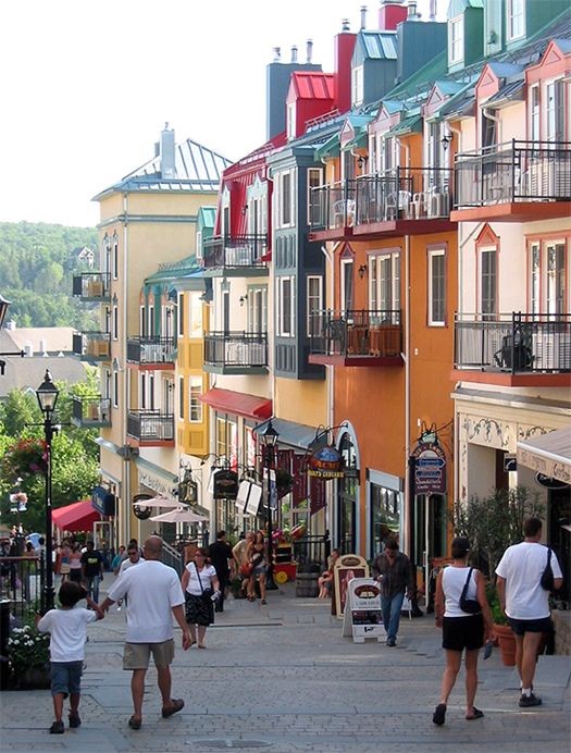
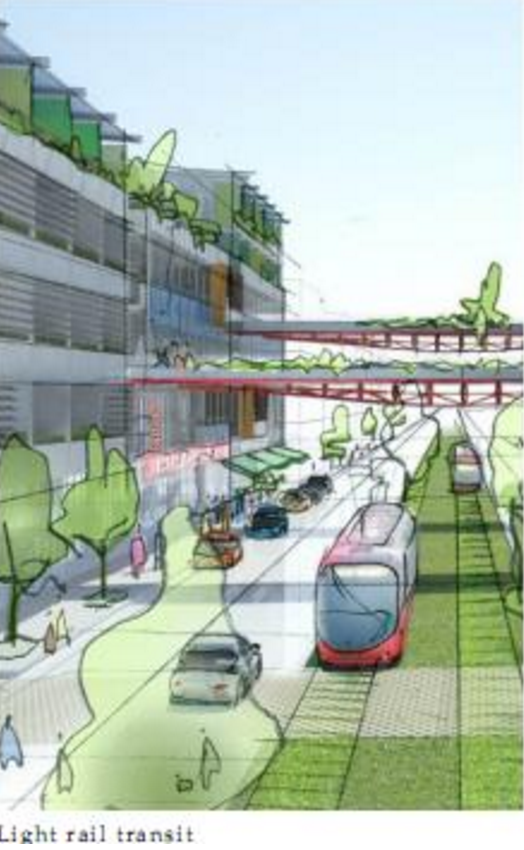
As you can see from the photo above, there was very little activity on Norwich. Beside our groups trekking around, I saw virtually no one on Norwich, and very few people around the Norwich and High intersection. I wanted to report and discuss this in the maps mini, but was unable. Picture this scenario to illustrate this shortcoming of the maps mini: Imagine if the street and intersection scored perfect across the board. There were crosswalks. There was tree coverage. There was no graffiti. But what if even with all this, there were still no people? On paper, the community would look great! But In reality it would be dead. This is why the paper should seek to capture the life of the community more than just infrastructure improvements.


Did you find public realm mattered more or less to you than private realm? Why?

Based on some of the poor upkeep of the public area I would say that the private area is valued more by the developers of this community. The houses seemed decent for the most part, but there were sidewalks that were very broken up, and not many trees. The public are did not seem like there was much funding or thought put into it. There were no parks close by, and there was no cross walk as you can see in the picture above.

5 Beers + 1 Coke personally values the development of the public are above private development. If you develop the public are to be a nice and attractive space, private businesses and people that really care about the community will move in. If the public area is attractive, the private will come. Money must be invested to jump start that process. But the private part will not initiate this process. Why would private firms take an unnecessary step of faith like that? It only makes sense that they would go to a part of the community that really focuses on development in the private sector.

What issues do you think would be more important to community members as opposed to planners?

Community members often value private free choice over plans. Issues about amount of land they have per parcel is more important to community members in rural areas. In the outskirts of central Ohio there are regulations for how big the parcels are in certain districts. Some of the people live on family land that has been there for generations. To these people, the regulations on the land are viewed as unconstitutional breaking of privacy. But to the planner, these regulations are for the good of the overall community development.  This example can be taken outside of the size regulation of parcels in certain districts. Another example could be people that want to paint their house a crazy pink color. The neighborhood may once again have regulations against that. The planner views these regulations as good because they help property values and keep a nice feel for the community. But some individual members may once again view this at breaching their private free choice.

high and norwich norwich Sidewalk (1)

Planned Neighborhood: “MAPS Mini” Blog #7

What’s missing from MAPS-Mini? What did you keep wanting to report but didn’t find on the survey tool?


We felt that the MAPS mini was useful in general, but was lacking questions about the safety of the street as a whole. By implementing more questions from the perspective of a pedestrian, we could plan the landscape in order to enhance the pedestrian experience through aesthetic and safety appeals. In addition, we believe that the survey did not focus enough on the safety of bicyclists, despite Scott Ulrich’s (Healthy Places Coordinator) constant emphasis on the importance of biking, especially within our university’s campus.

For our group, we thought that this picture effectively portrays the lack of awareness for pedestrians as well as cyclists along W Norwich.

For our group, we thought that this picture effectively portrays the lack of awareness for pedestrians as well as cyclists along W Norwich.


Did you find public realm mattered more or less to you than private realm? Why?

Planned Neighborhood believes that the public realm takes precedent over the private realm. If a planner turns most of their focus towards the public realm, then community members will be more inclined to the take care of their private realm. Because most people take pride in where they live, their community’s safety and appeal will be maintained, which subsequently pushes the community members to upkeep the private realm. Ultimately, the effort to maintain both the public and private realm contributes to creating a safer and cleaner community.


What issues do you think would be more important to community members as opposed to planners?


Essentially, a planner holds the responsibility of being the voice of the people that he or she serves. Because of this, it is hard to distinguish whose concern (the community members or the planners) is more important. A talented planner will listen to the concerns and opinions of the community and consequently implement those concerns into the landscape of the community.

A symbiotic relationship between a planner and the community members is essential in designing a safe and effective community.

A symbiotic relationship between a planner and the community members is essential in designing a safe and effective community.


The Chaire of Pierre : MAPS Mini Assignment

Question 1

What’s missing from MAPS-Mini? What did you keep wanting to report but didn’t find on the survey tool?

The MAPS-Mini is obviously an abbreviated version of the survey but it was lacking a lot of important questions about safety and parking. We feel that the parking situation determines a lot about the visibility of pedestrians and the general feel of the street. This also impacts the safety of pedestrians because it provides a barrier from traffic. Parking is an important factor especially for people who live on the immediate street and should be addressed.

 IMG9535441

Question 2

Did you find public realm mattered more or less to you than private realm? Why?

 The public realm mattered more to us because there is a lot less that city planners can do about existing private structures. We like to focus on public things that are actually able to be changed. The things in the public realm such as the beat and broken sidewalks and lack of pedestrian cross walks at both intersections were the things we were worried about most. These can be fixed with a little government intervention.

 IMG9535431

Question 3

What issues do you think would be more important to community members as opposed to planners?

Community members would be more interested in the aesthetic qualities of sidewalks, the buffer zone, and the general look of the street. Community members would also care more about safety, parks, and places to sit. Planners probably care more about traffic patterns, building setbacks, buffer zones and sidewalk size, along with all of the legality of their decisions in the planning of a busy down town street. It would be nice to see city planners also take into account the things that community members want in their area like Norman Krumholz from Cleveland advocated.

krumholtz

Planned Neighborhood – Blog 6

The charge of a planner is not only to design spaces with people in mind, but is equally concerned with designing spaces that people keep in their minds. Though there are correlational trends to draw in traffic, there is no set formula for providing a space with an attractive atmosphere. A space can be designed with every activator in record: water, shade, movable seating, etc. That same space can provide opportunities for recreation, entertainment, and commerce, or could just as well be planned expertly to mix these uses with residential zones. However, these spatial assets would be worthless if the area does not interest potential residents. An empty space is a wasted space.

The City of Dublin Planning Commission currently plans to undergo a dramatic re-designing of their “Bridge Street District.” In doing so, their aim is not only to attract the “best and the brightest” to the new district, but to retain residents. As such, they must resolve the issue in their design methods; they must prevent the new development from becoming an empty space. The site at hand is a 3.75 acre Greenfield located off of Dale Drive, zoned in the BSD Scioto River Neighborhood District. The site is bordered by residential and office zones.

When asked what should be placed in this site, the team answered with another question: What makes a district desirable? The team developed a hypothesis that it is a place’s distinctness, an intangible character present in streetscape and structure façades that creates an atmosphere which clearly defines the place in both space and time. What makes a place desirable is the fact that it is unlike anywhere else. It can be similar to another area, but the character of the district feels different than anywhere else in the metro area. As such, our team decided that a local history museum could be placed in that area. The museum would feature small installations regarding the history of Dublin, and Columbus, and feature works by local artists and community members. The bulk of the area would be devoted to an event center which could house travelling exhibitions and be available for reserved events, such as concerts, speaker series, weddings, workshops, or government meetings. Our team believes that the addition of a cultural space with a community center could tie together the homey, family-friendly characteristics already present in Dublin, as well as prompting community events geared towards a younger crowd. This land use is conveniently located to both an office sector as well as a residential district, allowing several members of the new district access to the space without creating a nuisance.

The Aqueduct by: The Chair of Pierre

The question of what to do with the 3.75 acre plot of land located in the Bridge Street district on Dale Dr. has multiple factors that influenced the decision we made. The Zoning of this parcel is technically BSD Scioto River Neighborhood District, but it is surrounded by office residential, commercial, and public zoning as well. The prime location of the parcel at the intersection of Bridge St. and The Scioto River probably has something to do with the convergence of all of these zones. The site seems prime for an attractive mixed-use project. The Scioto River is in-navigable and essentially economically useless, but its intersection with Bridge St. creates valuable land which the current use is under utilizing.

The Scioto And Olentangy Rivers are the foundation of Columbus, and Downtown, The Short North, OSU, and Dublin are all located by their banks and connected by their confluence. All of these areas have unique qualities that have resulted in outstanding development and prosperity in the past 20 years, but they are all separated and not in comfortable walking distance. The only way to access these areas currently is for everyone to drive their gas guzzling cars in traffic to each destination and crowd the area by parking their cars. Which is stupidly inefficient and an old idea of 20th century suburban life that the population’s preference is shifting away from. Also, many attractions in these areas are restaurants and bars that serve alcohol, and while everyone can pretend like people do not drunk drive, that is an event that happens too often. This system forces people to choose between staying close by and drinking, driving to a destination and not drinking, or driving to an area and then drunk driving home. We as a city need to learn from J.T. Barrett because great people do make mistakes, but if he had an alternative mode of transportation that could take him home from where the fun was…

cm14


The Aqueducts: Columbus’s first passenger rail line that connects the city’s points of interest along the Scioto on Olentangy Rivers. The largest problem with setting up a railway in Columbus is that there is already infrastructure such as roads, buildings, sewers, etc. everywhere in the way of any desirable path. Well, Columbus has been set up on the Olentangy and Scioto Rivers and many key points of the city are already on the banks of these barely used rivers. Obviously the rivers themselves would not serve as a transport for the trains. Large arches spanning over the river at intervals deemed structurally manageable would lift the railways above the river and frame it. The architectural style will be a tribute to Rome’s greatest innovation- The Aqueduct. Four key areas would need to be connected at the initial phase, the Arena district, the Short North, Ohio State University, and Dublin’s new Riverside District. Each of these areas have private and public entities that would be financially interested in connecting their business to the foot traffic a train station will bring, and each area has unique qualities that they can implore in their stations to symbolize their goals. The general format for each station would be.. an elevated structure to match the height of the rail lines which funnels into the centralized boarding hub for the train system. Underneath the structure would be a sturdy foundation that stored ample parking. The foundation should take the ground space and elevate it, similar to how Elis S. Chesbrough lifted the skyline of Chicago to install it’s first sewer system. On this lifted structure will be a mixed use space that is a central train station surrounded by a retail center, community center, and recreational park space.

Each area can tailor their station to their needs and desires, which the city of Dublin can use to fit their needs as the most suburban of the key areas. The historic district in Dublin is a a very desirable spot and has potential to be a great place, but it has to compete with the many attractions down town has to offer. The young professional crowd that Dublin is trying to allure is always going to have that draw to downtown, and no number of “cool office parks” or breweries will change that. What it does have to offer is a quaint area with a stable economy that is a nice place to become a real adult, so Dublin should stop trying to create attractions, and rather focus on connecting it’s cool new Riverside District with the existing great attractions that OSU, the Short North, and downtown already possess.


Explore Nation: The Bridge Street District

We found that the three acre greenfield plot could have a few different uses. The surrounding area doesn’t include many places for entertainment, so we decided to focus on that aspect. The idea of a concert/entertainment center and venue would work well on the plot and in the context of the surrounding district. This venue would be made up of an indoor theatre area which includes a restaurant/bar and also an outdoor theatre venue. This site would be very suitable for professional young adults who are looking for something fun and entertaining to do. In addition, the venue would bring in more money and revenue to the area, along with some interesting performances and events.

We also thought that it’d be interesting to create a playground made for adults on this site. It’s been a pretty big hit in other cities around the nation, and it could be an important addition to this district. This playground or recreational jungle gym would include adult-sized, mature playground equipment that can be used by the young professionals living in this area. It would be a nice place for these young adults to spend their leisure time, a place where people can let off steam and get rid of some stress.

Another idea we had was to transform the area into a grocery store that could be used by the residents living in the district. There aren’t many walkable grocery stores in the surrounding area, so one on this site would make sense and be very suitable for this area. 

grocery1grocery2


New Kids on the Block: Mixed Use Village

The New Kids on the Block came up with an interesting way to use this land on the lot in the picture below. The idea that this district wants to be more welcoming and enjoying, we figured that having an all-in-one mixed use area would attract people to come the Bridge District.

Screen Shot 2015-11-02 at 7.09.19 PM


The mixed used pedestrian villa will contain two lines of buildings in range from five through eight stories. The common use is from residential to commercial and office use. There will also be a Recreational center that welcomes public use and all parking is proposed to be in the rear leaving the in-between space for pedestrian use. Bridge District will propose night live attraction, with Shoppe’s, dining, recreation, theatre, and brewery.

village

Some elements that will make this village appeal to tourist and the people living in the communities are defined keys of Dublin. We would use materials like older stone and as well as modern stone to present character. We’ll also present lamp posts to help light the area at night.

Urban Avengers: The Bridge Street District – Attracting Millennials and Young Professionals

Screen Shot 2015-11-02 at 7.09.19 PM

For this 3.75-acre site in the Bridge Street District, we propose a new, outdoor green space. The focus of this feature is an open amphitheater with an over-hang for entertainment.

cape-coral-stage

On roughly half of the site would sit the amphitheater, which could be used for live concerts, plays, and local attractions. In addition, towards the front of the stage there would feature a retractable screen to serve as an outdoor cinema. The base of the structure would be brick to tie into the surrounding Bridge Street District buildings and residencies.

rgwhatthetruck-8434934

To the rear of the amphitheater would be either an area with permanent concession stands for events or a parking area for food trucks. While the amphitheater would be substantial enough to host live music, it would not be large enough to bring big acts or tourists to the area.

Our new proposal would create a gathering site for young professionals to enjoy the outdoors and generate a sense of community, while also serving as a friendly area for those with families. Overall, it would give the community a gathering place of their own to interact with each other.

The Diamond Developers: The Bridge Street District


      Our group has come up with an innovative idea to make sure The Bridge Street District thrives. We propose the 3.75 acre lot located in the middle of the district be turned into a light rail station. The rail line would link Dublin to other parts of Franklin County, including OSU and downtown Columbus. This would lead to growth and tourism in the city of Dublin as well as a modern connection between the large, influential suburb and the major job and tourism areas of Ohio State and downtown. On top of the benefits to the economy, residents that live in The Bridge Street District, and all of Dublin, will have an easy way to commute to their jobs. This would be revolutionary for the city of Dublin, and all of Central Ohio.

train

      We understand that a light rail line won’t happen overnight, so this would be built as a flexible space in order to make economic sense until the line comes. The rail station would have space for several local shops and restaurants that people could easily walk to and enjoy. Also, because this lot is relatively large, space could be set aside for a park, adding to the community feel and allowing for  space to gather.

      When the time does come to make this a light rail station, some adjustments on the interior can make way for the trains and track can be laid. We see this as an opportunity for the city of Dublin to work with the city of Columbus and COTA to bring an innovative and necessary alternative to cars to the Columbus area. This busy and crowded area of the city, including the Sawmill Road corridor, can become the leading example in Ohio of smart and innovative urban planning. Adding light rail would be a catalyst for more development, higher densities, and other rail lines, as well. This is Dublin’s signature project; the city should make it loud and clear that they are on a path to a better future. This would be that statement to Columbus and the rest of the state that they are on the forefront of building a better tomorrow.

Screen Shot 2015-11-02 at 7.24.51 PM

Dublin Plan for attracting Millennials and Young Professionals: 5 Beers and A Coke

For the Dublin city plan we plan to propose a way to attract millennials and young professionals by encouraging the night life and creating a small arts district. We would like to add a theater and a community center/country club for the residents of Dublin. We want to include a microbrewery to add to the local nightlife. There will also be a bike track that connects to the bridge St. Parkway exclusively for the “pedal wagon” to have a fun and unique experience for the residents for Dublin during their celebratory events.

2618373-3921371477