Author: Maria Walliser-Wejebe
Planned Neighborhood: COTA Transit Audit
Our group, Planned Neighborhood, was scheduled to start our journey at the bus stop on 11th Avenue and High Street at 3:55pm. As most of us walked down High Street, a COTA bus passed us going southbound. Most of the group arrived at the stop around 3:53, and there was no bus to be found. We soon realized that the #2 line was running nearly 4 minutes early and that we had barely missed the 3:55 bus that we intended on taking. The stop was decently kept with benches, a shelter to protect from the elements, trashcans, disabled user seating, and schedules to update riders. The stop felt safe in the afternoon, however, would have minimal lighting for the evening time.
![IMG_20151116_225434[1]](https://u.osu.edu/crp2110/files/2015/11/IMG_20151116_2254341-22h59g9.jpg)
![IMG_20151116_225428[1]](https://u.osu.edu/crp2110/files/2015/11/IMG_20151116_2254281-2kgp2jc.jpg)
The next bus that arrived showed up at 4:09 pm. This was six minutes later than was posted. At this point our trip has lasted for around 14 minutes and we had just gotten onto the bus. As we entered, the driver greeted us and was very polite. The bus was very crowded with barely any standing room in either the front or the back. There were passengers riding that were from many walks of life, varying in age, race, and perceived socioeconomic status. The sounds of the bus were those of private conversations, which gave an overall muffling sound. A lightboard at the front of the bus gave the date, time of day, and the name of the upcoming stop, which was accompanied by an automated audio recording. This feature made it very simple to recognize where we were along the route. The bus was crowded and loud, but well lit. The smell was moderately stale with the fragrance of sweat, food, or colognes and the seats had fabric coverings. Most riders looked tired as we descended downtown, probably due to long day of work. We rode the #2 line for a few stops, enjoying the city scenes and the company of its residents. The only time the bus remained at a scheduled stop for an unreasonable amount of time was when a disabled elderly woman with a walker took time to board the bus and pay fees, and then was unable to settle in the designated disability spot on the bus due to crowding. We exited the bus on the intersection of Broad and High St.
![IMG_20151116_225351[1]](https://u.osu.edu/crp2110/files/2015/11/IMG_20151116_2253511-1iqxod2.jpg) The stop was well kept, much nicer than the original stop. There were plenty of covered benches to sit, trashcans, route schedules, and it was very well lit. We all felt very safe and were aware of our surroundings. The connecting #7 line came immediately after we stepped off of the #2 line bus. The #7 was much less crowded than the previous bus. This model of bus was slightly older but was kept very nice over time. The smell was not as stale as the other bus, probably because there were a few windows cracked. The driver was polite as we entered the front doors, asking us how our day had been and making casual conversation. The bus was moderately lit, which could make some passengers feel uneasy, as one side was irregularly dark during transit. Although there were fewer riders on this line, the vehicle was much louder due to the nature of the younger kids riding. We continued on our journey as we approached the outskirts of the German Village. We arrived at our destination within minutes; the Post Office near Whittier and Parsons Ave. Our Arrival time was approximately 4:52, indicating that the first leg of our trip took nearly 40-45 minutes.
The stop was well kept, much nicer than the original stop. There were plenty of covered benches to sit, trashcans, route schedules, and it was very well lit. We all felt very safe and were aware of our surroundings. The connecting #7 line came immediately after we stepped off of the #2 line bus. The #7 was much less crowded than the previous bus. This model of bus was slightly older but was kept very nice over time. The smell was not as stale as the other bus, probably because there were a few windows cracked. The driver was polite as we entered the front doors, asking us how our day had been and making casual conversation. The bus was moderately lit, which could make some passengers feel uneasy, as one side was irregularly dark during transit. Although there were fewer riders on this line, the vehicle was much louder due to the nature of the younger kids riding. We continued on our journey as we approached the outskirts of the German Village. We arrived at our destination within minutes; the Post Office near Whittier and Parsons Ave. Our Arrival time was approximately 4:52, indicating that the first leg of our trip took nearly 40-45 minutes.
![IMG_20151116_225457[1]](https://u.osu.edu/crp2110/files/2015/11/IMG_20151116_2254571-18y66tn.jpg)
It was time to head home. We decided that the easiest route to take home would be to ride the #7 line all the way back to campus. The next bus would come at 5:03. The stop that connected us to the returning line was poor in quality. The stop was marked by a sign. It was a chilly evening and with the wind blowing we stood in the cold, as there was no covered shelter to sit under. Next to the stop, there was a brunch delicatessen with an awning in front of the front door, where members of our group took shelter from the wind, not boding well for the business’ appearance. ![IMG_20151116_225344[1]](https://u.osu.edu/crp2110/files/2015/11/IMG_20151116_2253441-11fjhd2.jpg)
![IMG_20151116_225333[1]](https://u.osu.edu/crp2110/files/2015/11/IMG_20151116_2253331-1e346ob.jpg) At night this stop would be a little unsettling, especially for someone who wasn’t familiar with the area. Finally, the #7 line returning to campus arrived. It pulled in 4 minutes late leaving us with a departure time of 5:07. This bus was calm. Only a few additional riders were on the bus back. These riders were reading, listening to music, or just sitting quietly alone. The bus was one of the older models but, again, well kept. It didn’t have an overwhelming smell or sound, just the hum of the bus wheels turning. The driver greeted us politely as we entered, but you could tell that he was getting tired. We continued on our path back to campus. Passing stops here and there. We eventually arrived back at the Ohio Union around 5:35pm. Nearly two hours had elapsed from when we departed, to when we finished. Overall, we were happy to see how easy it was to make it to our destination; we were unimpressed however by how long the routes took. The COTA is a great resource for Columbus residents. One who plans on using the transportation should always be early to ensure that they will make their bus, as schedules can be somewhat unreliable. Likewise, the COTA transit system is not an option for someone on a time crunch; had we been riders who depended on public transportation, we would have arrived significantly late to any event we had scheduled at the intended return time of 5:15pm. There was also a notable problem of crowding on the #2 line at the beginning of our journey, which made it difficult to board/find seating/get off the bus, especially for elderly or disabled riders. Overall, the COTA system is taking strides in city transportation but could use tweaking to make it more equitable and timely.
At night this stop would be a little unsettling, especially for someone who wasn’t familiar with the area. Finally, the #7 line returning to campus arrived. It pulled in 4 minutes late leaving us with a departure time of 5:07. This bus was calm. Only a few additional riders were on the bus back. These riders were reading, listening to music, or just sitting quietly alone. The bus was one of the older models but, again, well kept. It didn’t have an overwhelming smell or sound, just the hum of the bus wheels turning. The driver greeted us politely as we entered, but you could tell that he was getting tired. We continued on our path back to campus. Passing stops here and there. We eventually arrived back at the Ohio Union around 5:35pm. Nearly two hours had elapsed from when we departed, to when we finished. Overall, we were happy to see how easy it was to make it to our destination; we were unimpressed however by how long the routes took. The COTA is a great resource for Columbus residents. One who plans on using the transportation should always be early to ensure that they will make their bus, as schedules can be somewhat unreliable. Likewise, the COTA transit system is not an option for someone on a time crunch; had we been riders who depended on public transportation, we would have arrived significantly late to any event we had scheduled at the intended return time of 5:15pm. There was also a notable problem of crowding on the #2 line at the beginning of our journey, which made it difficult to board/find seating/get off the bus, especially for elderly or disabled riders. Overall, the COTA system is taking strides in city transportation but could use tweaking to make it more equitable and timely.
Planned Neighborhood: Blog 5, Brownfield Redevelopment Update
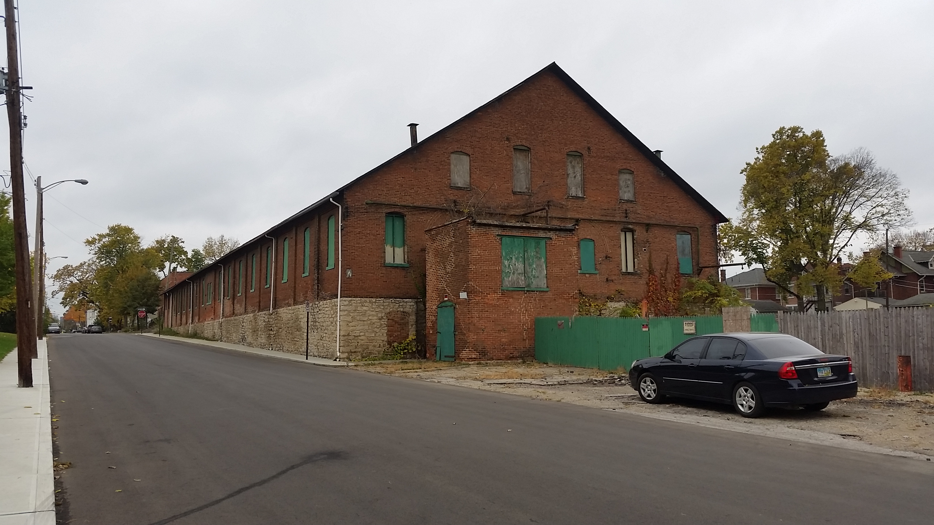
The current site is located on the East Side of Columbus, near the Franklin Park Conservatory and Bexley, OH. The site is accessible through Oak Street and Kelton Avenue. There are three brick buildings on the site in various states of disrepair, the foliage on site is overgrown, and there is litter in and around the area. The Trolley Barn Block Watch set up with the 12th Precinct of Columbus police covers the neighborhood surrounding Franklin Park, lowering crime levels in and around the site.

Street view of the current lot

Street view of the current lot
Our group has the vision of creating a space that will not only stimulate the economy of the area, but work towards building a vibrant and cohesive community. We imagine spaces that will narrow divides and provide a forum for unity. Planned Neighborhood aims to develop a local produce hub along with a community-learning center. In addition our plan is to include a local brewery and tap house that will provide the nearby residents with a relaxing get away from their normal hustle and bustle. This development will be named The Trolley Barn Block.

The Westernmost side of the site will house our Barn Brewery and parking area.

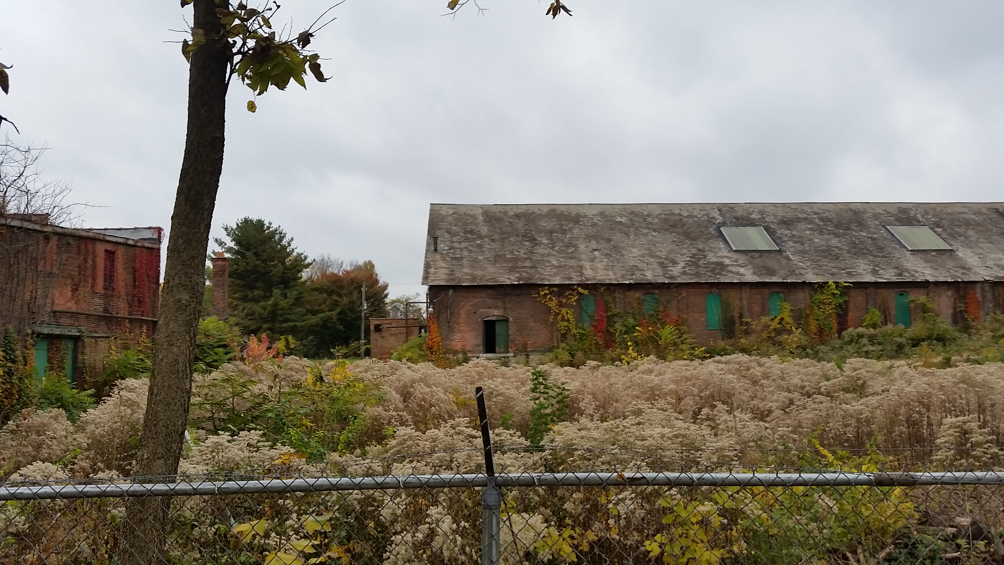
Current conditions, westernmost building
Current conditions, westernmost building

Bar name and logo

Redevelopment proposal, front view
The more centralized region of the site will be the home of our community gardens, where local gardeners can purchase a small plot to grow crops, herbs, and flowers. Located in the middle of the site, this area should get moderate sunlight in the middle of the day and shade in the dusk/dawn periods. Provided the soil is thoroughly tested, this area could support carrots, radishes, beets, broccoli, cauliflower, and leafy vegetables, some of which, including carrots and radishes, grow into the winter months, allowing for sustainable returns of produce. Considering the size of the site, yields would be modest, supporting the small market on a weekly, or every-other-week basis.

Current conditions, mid site
Current conditions, mid site
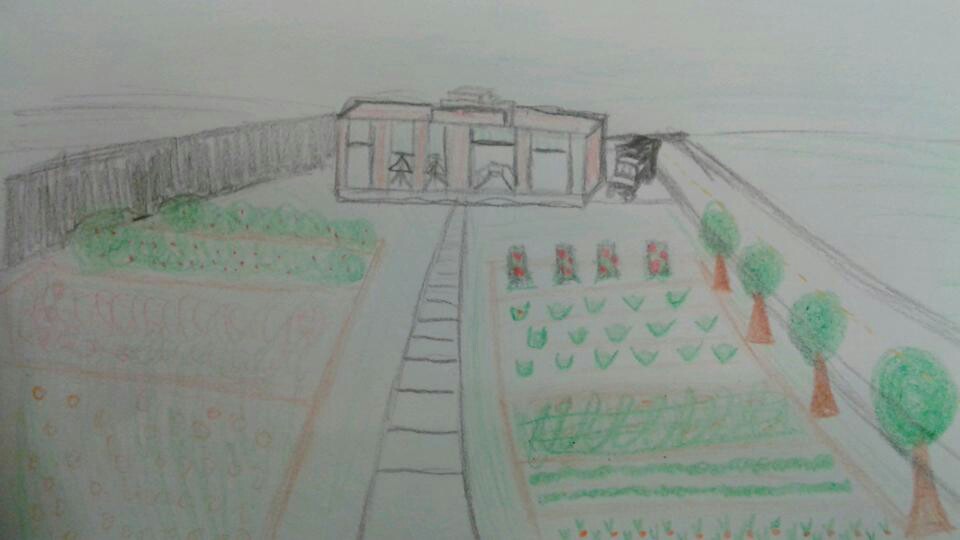
Redevelopment proposal
Located on the easternmost region of the site will be the proposed Trolley Car Market, Community Center, Learning Kitchen, and a loading dock to support deliveries to the market. The Learning Kitchen will act as an instructional site where families can learn about healthy eating options and how to prepare fresh meals. The Community Center is intended to be used as a space for family gatherings, community events, etc. to support healthy attitudes towards food and to promote the benefits of supporting local growers.

Current conditions, easternmost building

Current conditions, easternmost building

Market name and logo

Redevelopment proposal, front view
The re-purposed brownfield site will be accessible through many modes of transportation, but geared mainly towards those who use non-motorized transportation and public transit. Our consumers will be able to travel to the site on bus, by bike, driving, or with a quick walk. There will be parking amenities for both for bikes and cars, as well as street parking available in the case of lot overflow.

Redevelopment Site Plan
We imagine that although many neighbors will greatly favor our proposal, there will be skeptics. One concern could be that because this site is a brownfield, chemicals and toxins could have infiltrated the ground making it unsafe to grow healthy crops. We have a plan to clean the area of toxins through soil treatments, growth of plants that will revitalize the plots, transporting non-toxic dirt to the site, and the use of compost to create a healthy soil for our families. The compost will be provided from the market and brewery leftovers. Another concern might be that our site will bring in traffic and increase pedestrian visits in what is a relatively calm neighborhood. Although we do hope to bring traffic to the area, our plan is to create a serene space that one can visit to relax, run errands, or learn. In addition, we have taken measures that will act as a buffer to minimize noise from inside the development such as lining the site borders with trees and shrubbery. Finally, we understand that the brewery could have negative connotations associated with it. Our vision for the brewery is to have a tap house/restaurant location that would offer an inviting and relaxed atmosphere. This would be a family restaurant and have a separate brew room were customers could indulge in a few beverages. The establishment would have normal business hours, closing at ten on weekdays and midnight on the weekends, to respect the neighbors and reduce commotion and noise. This facet of the proposal would, of course, first have to gain public support at a neighborhood meeting, but we feel we could provide enough benefits to prove the Barn Bar an asset to the site and the neighborhood.
Overall, we know that the Trolley Barn Block will pay tribute to its roots but add a modern twist to the present neighborhood. We want our guests to be able to see landmarks such as the trolley barn and know that was the same trolley barn that their grandparents passed walking home from church each Sunday. In addition, we want to create a space that will one day be a lasting asset for the community and be a new piece of history for the site.
Planned Neighborhood Blog 5: “A Brownfield goes Green”
While arriving at the brownfield site on Kelton and Oak many emotions come to mind. One might feel scared, hopeless, disinterested, or solemn. The surrounding neighbors seem to have an evident divide. Looking through the lens of planner, however, one can see potential for a thriving site that will contribute to a much deserving community.
Street view of the current lot
Street view of the current lot
We have the vision of creating a space that will not only stimulate the area economically, but as a community. We imagine spaces that will narrow divides and provide a forum for unity. Planned Neighborhood aims to develop a local produce hub along with a community-learning center. In addition our plan is to include a local brewery and tap house that will provide the near by residents with a relaxing get away from their normal hustle and bustle. This development will be named The Trolley Barn Block.
The Westernmost side of the site will house our Barn Brewery and parking area.
Current conditions, westernmost building
Current conditions, westernmost building
Bar name and logo
Redevelopment proposal, front view
The more centralized region of the cite will be the home of our community gardens, where local gardeners can purchase a small plot to grow crops, herbs, and flowers.
Current conditions, mid site
Current conditions, mid site
Redevelopment proposal
On the Eastern most region of the site will be located the Trolley Car Market, Community Center, learning Kitchen, and Loading Dock. The learning kitchen will act, as an instructional site where families can learn about healthy options and how to prepare fresh meals. Our Community center will be used as a space for family gatherings, community events, etc.
Current conditions, easternmost building
Current conditions, easternmost building
Market name and logo
Redevelopment proposal, front view
This Brownfield Site will be accessible through many modes of transportation. Our consumers will be able to travel to the site on bus, by bike, driving, or with a quick walk. There will be parking amenities for guests, both for bike and cars, as well as street parking in case of overflow.
Redevelopment Site Plan
We imagine that although many neighbors will greatly favor our proposal, there will be skeptics. One concern could be that because this site is a brownfield, chemicals and toxins could have infiltrated the ground making it unsafe to grow healthy crops. We have a plan to clean the area of toxins through soil treatments, growth of plants that will revitalize the plots and the use of compost to create a healthy soil for our families. The compost will be provided from our Farmers Market and Brewery leftovers. Another concern might be that our site will cause commotion in what is a relatively calm neighborhood. Although we do hope to bring traffic to the area, our plan is that we will create a serene space that one can visit to relax, run errands, or learn. In addition, we have taken measures that will act as a buffer to minimize noise from inside the development such as trees and shrubbery. Finally, we know that the brewery could have a negative stigmas associated with it. Our vision for the Brewery is to have a tap house restaurant location that would have an inviting and relaxed feel. This would be a family restaurant and have a separate brew room were customers could indulge in a few beverages. The establishment would have normal business hours, closing at ten on weekdays and midnight on the weekends, to respect the neighbors and reduce commotion and noise.
Overall, We know that the Trolley Barn Block will pay tribute to its roots but add a modern twist to the present neighborhood. We want our guests to be able to see landmarks such as the trolley barn and know that was the same trolley barn that their grandparents passed walking home from church each Sunday. In addition, we want to create a space that will one day be a lasting asset for the community and be a new piece of history for the site.
Planned Neighborhood: Assignment 4 Local Neighborhoods and Food Environments
![IMG_20150920_192701[1]](https://u.osu.edu/crp2110/files/2015/09/IMG_20150920_1927011-28auhlk.jpg)
Weinland Park, a neighborhood directly north of downtown Columbus and east of the Ohio State University campus area, stretches from 5th Avenue to 11th Avenue, south to north, and from High Street to 5th Street, east to west, and has 35,771 residents. The neighborhood is characterized by poverty, the median household income coming to around $23,394, half that of the median income of the city of Columbus. The population of Weinland park is predominantly Black, with 36.1% of the population being single-mothers. Simply put, the neighborhood has room for improvement.
The neighborhood is cut by two 3-lane, one-way streets, Summit and Fourth Streets. There are no bike lanes, the sidewalks show signs of low maintenance, there are a few spread out light posts, and crosswalks are few and far between. There are two Central Ohio Transit Authority (COTA) routes that pass through the area, but the stops are spread out, and do not connect the neighborhood with amenities of the surrounding areas. Unless you own a car, transportation in, out, and through the neighborhood is limited to pedestrian and bike traffic.
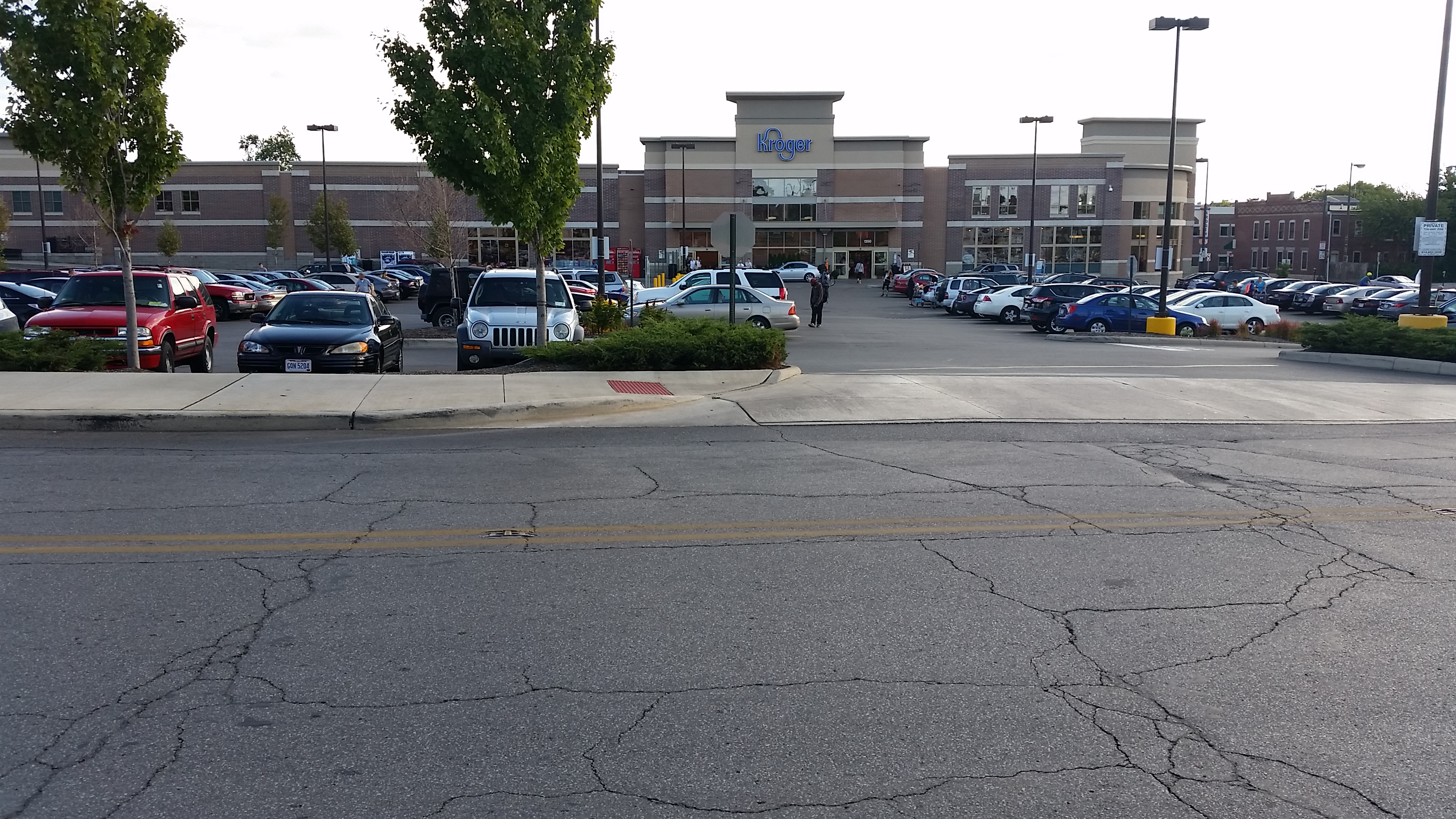
There is one accessible grocery store in the area, a Kroger on High Street and King Avenue. The Kroger gives the residents of Weinland park access to fresh fruits, meats, and produce, as well as conventional grocery store needs. Kroger is accessible by car or by non-motorized transport, albeit a far walk. Besides the grocery store, Weinland park doesn’t have very many locations to access healthy foods. There are gas stations and carry-outs sprinkled throughout the area, but the selection of food stuffs that they offer is lacking in nutritional value. This would make the area relatively food insecure, because of the limited availability of locations to purchase food and the size of the population. The Kroger on King Ave is great for residents who live within a four block radius, but without convenient public transportation routes or a vehicle, it becomes difficult to trek ten blocks there and back in the middle of December. Weinland Park, therefore, could be categorized as a “food swamp,” where there is food available to residents, but because of location and the socioeconomic standings of the residents, the available food is limited in nutritional value.
There are efforts, though, to change this neighborhood for the better. Zoom in to 1379-1381 North 4th Street, or, as it is known by members of the community, Fourth Street Farms. Started by Jai Woody Drake and his life partner, the couple purchased an empty lot from a neighborhood cooperative and began, slowly, to improve the food system of Weinland Park. Fourth Street Farms grows locally obtained and organically feed fruits, vegetables, and herbs on a volunteer-basis, and makes its food available to the community. The farm prides itself on being open to anyone on the street. “There are no fences,” states farm founder Drake. The farm gives fresh produce to the immediate community, improving the food system of Weinland Park. Fourth Street Farm runs on the motto “food eaten is not wasted,” and has become a community defining location within the neighborhood.
![IMG_20150920_192655[1]](https://u.osu.edu/crp2110/files/2015/09/IMG_20150920_1926551-2gwzwyx.jpg)
![IMG_20150920_192718[1]](https://u.osu.edu/crp2110/files/2015/09/IMG_20150920_1927181-262gw65.jpg)
![IMG_20150920_192710[1]](https://u.osu.edu/crp2110/files/2015/09/IMG_20150920_1927101-si1glq.jpg)
There are more and more gardens and community farms popping up around the area, including one on Euclid Avenue and one on 6th Avenue. In the future, these farms can form a coalition and set up bi-monthly farmers’ market in a central place in the community, like the park or in a “block party” setting. These farms, though revolutionary and incredibly important to the community, are ineffective in that they shut down four months out of the year. Therefore, other proposed ideas include building another grocery store in the area, one that is especially compatible with WIC and EBT programs to provide for the needs of the community, to increase bus stops to and from available grocery stores, and starting a “Produce Food Truck” which takes a loop through the neighborhood selling fresh fruits and vegetables, obtained either from community farms and/or the Kroger, to residents.
![IMG_20150920_211045[1]](https://u.osu.edu/crp2110/files/2015/09/IMG_20150920_2110451-2a6td66.jpg)
Current Set-up of Weinland Park
![IMG_20150920_211037[1]](https://u.osu.edu/crp2110/files/2015/09/IMG_20150920_2110371-2jorlvq.jpg)
Proposals for the Weinland Park area
![IMG_20150920_211053[1]](https://u.osu.edu/crp2110/files/2015/09/IMG_20150920_2110531-oqd789.jpg)
Produce Food Truck